Kai Islands
| Native name: Kepulauan Kai | |
|---|---|
 The Kai Islands | |
 | |
| Geography | |
| Location | South-east Asia |
| Coordinates | 5°45′S 132°44′E / 5.75°S 132.73°E |
| Total islands | 47 |
| Major islands | Kai Besar, Kai Kecil |
| Area | 1,438 km2 (555 sq mi) |
| Highest elevation | 90 m (300 ft) |
| Highest point | 90 meters altitude |
| Administration | |
| Province | Maluku |
| Largest settlement | Alaku Malaki |
| Additional information | |
| Time zone | |

The Kai Islands (also Kei Islands) of Indonesia are a group of islands located in the southeastern part of the Maluku Islands in Maluku Province.[1][2] The Malakus have also been known as the Spice Islands due to regionally specific plants such as nutmeg, mace, and cloves that originally intrigued the European nations of the 16th century.[3]
Though originally Melanesian,[4] many islanders were exterminated in the 17th century during the spice wars, particularly in the Banda Islands. A second influx of Austronesian immigrants began in the early twentieth century under the Dutch and continued in the Indonesian era.
Government and Administration
The islands consist of the Southeast Maluku Regency (Maluku Tenggara) within the Maluku Province. The Regency is sub-divided into six districts (kecamatan). Though geographically within the Kai Islands, the city of Tual is the capital of the Southeast Maluku Regency of Indonesia, but not a member of the regency.
Geography
The Kai Islands are a part of the Wallacea, the group of Indonesian islands that are separated by deep water from both the Asian and Australian continental shelves, and were never linked to either continent. As a result, the Kai Islands have few native mammals and are a part of the Banda Sea Islands moist deciduous forests ecoregion. Kai Besar in particular is mountainous and densely forested. Kai is also famous for the beauty of its beaches, notably in Pasir Panjang.[5]
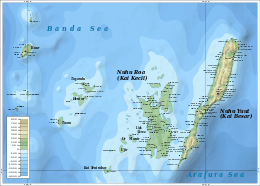
Inhabitants called the islands Nuhu Evav (Evav Islands) or Tanat Evav (Evav Land), but they were known as Kei to people from neighboring islands. The islands are located on the edge of the Banda Sea, south of the Bird's Head Peninsula of New Guinea, west of the Aru and Tayandu Islands, and northeast of the Tanimbar Islands.
The Kai islands are made up of numerous islands, including:
- Kai Besar or Nuhu Yuut or Nusteen (Great Kai)
- Kai Kecil or Nuhu Roa or Nusyanat (Little Kai)
- Tanimbar Kai or Tnebar Evav
- Kai Dulah or Du
- Dulah Laut or Du Roa
- Kuur
- Taam
- Tayandu Islands (Tahayad) groups
The Kai Islands' total land area is 1,438 km2 (555 sq mi).
Climate
The islands are located in a tropical area near the equator where there is little change in the weather throughout the year. The year round temperature is usually around 30 °C (86 °F), with the lowest temperatures reaching 18 °C (64 °F). There is a dry season that lasts from April to September, during which rain is scarce.
Culture
History

Local history holds that ancestors of contemporary Kai islanders came from Bali, part of the expanding Majapahit kingdom from the western archipelago. The village of Ohoi-Ewur (first Raja Ewab: Raja Ohoi-Ewur = Raja Tabtut) on Kai Kecil or Nuhuroa island was the arrival point for the Balinese royal family and their army. They stayed in the village with local residents. As a result, Ohoi-ewur became a seat of government, where the local law (Larvul Ngabal) – Red Blood and Balinese Spear – was developed at the initiative of the royal princess D it Sakmas.
Evidence for these stories include an inheritance and a harbor named Bal Sorbay (Bali Surabaya) on Kai Kecil which is, presumably, the harbor at which the royals arrived.
It is recognized by Kai islanders that some of their ancestors also came from other places such as Sumbawa island (Sumbau), Buton (Vutun) in Sulawesi, Seram (Seran) and Gorom (Ngoran) islands in the Central Moluccas, and the Sultanates of Jailolo (Dalo) and Ternate (Ternat) as well.
The tiny island of Tanimbarkei is not part of Tanimbar, as the name might suggest but is, in fact, one of the Kai Islands. It is inhabited by fewer than 1000 very traditional people. Half of the population call themselves Hindus, but in fact are more or less practicing ancestor worship.
After the 1999 clashes between the Muslim and Christian populations in Ambon, similar inter-communal clashes also swept through Kai, but quickly calmed down.
All of the islands depend on 22 ratshcaap, or traditional local leaders called Rat or Raja, as kings of customary law.
Languages
The official language in the Kai Islands is Indonesian, although local languages also exist between regions.
Three Austronesian languages are spoken on the Kai Islands; Keiese is the most widely spoken, in 207 villages on Kai Kecil, Kai Besar, and surrounding islands. Kurese is spoken on Kur Island and nearby Kaimeer, where Kai is used as a lingua franca. Bandanese is spoken in the villages of Banda-Eli (Wadan El) and Banda-Elat (Wadan Elat) on the west and northeastern side of Kai Besar. Banda speakers originally came from the Banda Islands, but the language is no longer spoken there. There is no native writing system for the Keiese Language. Dutch Catholic missionaries write the language using a variation of the Roman alphabet.
Musical Instruments
Some Kai musical instruments include:
- Savarngil: A small native flute from 10 to 20 centimeters (4 to 8 inches) long, open at both ends and having six fingerholes placed along the pipe made of bamboo and are keyless.
- Tiva: Single headed drums, consist of a calf skin membrane which is stretched over an enclosed space or over one of the ends of a hollow vessel.
- Dada: A medium-size gong 30 to 38 centimeters (12 to 15 inches) in size, with a crashing sound, have a raised boss or nipple in the center.
Religion
The major religion that dominates these islands is Christianity. The Kai are among the few islands in the region to have more Catholics than Protestants; they are regarded as the center of Catholicism in all of Maluku. Muslims present in this region are minor and they follow the mild form of Islam because they rarely have veiled women and mosques are low key affairs too.
Agriculture
The soil on Kai Kecil is of poor quality; slash-and-burn agriculture is still common. Fishing is usually done around Trepang, and cultured pearls are harvested in Kai Kecil.
Meiti Kei
A phenomenon that the seawater recedes up to 6 kilometers, so someone can go to other island by walking is done every year and is called as Meiti Kei. In 2017, the phenomenon will occur on October 22 to 23.[6]
See also
References
Notes
- ↑ "Indonesia: The Kai Islands (Kei Islands) « This Boundless World". thisboundlessworld.com.
- ↑ Administrator. "Maluku Travel Information - Kei Islands - East-Indonesia.info". east-indonesia.info.
- ↑ "Introducing Maluku". Lonely Planet. Retrieved 18 April 2015.
- ↑ IRJA.org Archived 14 April 2009 at the Wayback Machine.
- ↑ "Maluku and The Kai Islands on indahnesia.com".
- ↑ "Kei Islands still a hidden gem waiting to be explored". August 2, 2017.
External links
| Wikivoyage has a travel guide for Kei Islands. |