Bocholt, Belgium
| Bocholt | |||
|---|---|---|---|
| Municipality | |||
 | |||
| |||
 Bocholt Location in Belgium | |||
|
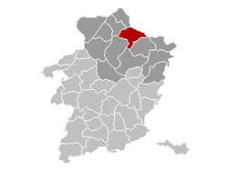
Location of Bocholt in Limburg  | |||
| Coordinates: 51°10′N 05°35′E / 51.167°N 5.583°ECoordinates: 51°10′N 05°35′E / 51.167°N 5.583°E | |||
| Country | Belgium | ||
| Community | Flemish Community | ||
| Region | Flemish Region | ||
| Province | Limburg | ||
| Arrondissement | Maaseik | ||
| Government | |||
| • Mayor | Jos Claessens | ||
| • Governing party/ies | Nieuwe Unie, SPa | ||
| Area | |||
| • Total | 59.34 km2 (22.91 sq mi) | ||
| Population (1 January 2016)[1] | |||
| • Total | 12,917 | ||
| • Density | 220/km2 (560/sq mi) | ||
| Postal codes | 3950 | ||
| Area codes | 089 | ||
| Website | www.bocholt.be | ||
Bocholt is a municipality located in the Belgian province of Limburg. On January 1, 2006, Bocholt had a total population of 12,355. The total area is 59.34 km² which gives a population density of 208 inhabitants per km².
The Priory of Our Lady of Klaarland of the Trappistins is located in Bocholt. Martens brewery established in 1758 has the second highest production capacity in Belgium at 360 million liters per year.
References
- ↑ Population per municipality as of 1 January 2016 (XLS; 397 KB)
External links
-
 Media related to Bocholt, Belgium at Wikimedia Commons
 - Official website - Available only in Dutch
| Adjacent places of Bocholt, Belgium | ||||
|---|---|---|---|---|
 |
Neerpelt | Hamont-Achel, Cranendonck (NL-NB) | Weert (NL-LI) |  |
| |
Kinrooi | |||
| ||||
| | ||||
| Peer | Meeuwen-Gruitrode | Bree | ||
This article is issued from
Wikipedia.
The text is licensed under Creative Commons - Attribution - Sharealike.
Additional terms may apply for the media files.

_wapen.svg.png)
