Katsdorf
| Katsdorf | ||
|---|---|---|
|
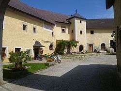
Breitenbruck castle courtyard | ||
| ||
 Katsdorf Location within Austria | ||
| Coordinates: 48°19′01″N 14°28′27″E / 48.31694°N 14.47417°ECoordinates: 48°19′01″N 14°28′27″E / 48.31694°N 14.47417°E | ||
| Country | Austria | |
| State | Upper Austria | |
| District | Perg | |
| Government | ||
| • Mayor | Ernst Lehner (ÖVP) | |
| Area | ||
| • Total | 14.61 km2 (5.64 sq mi) | |
| Elevation | 306 m (1,004 ft) | |
| Population (14 June 2016)[1] | ||
| • Total | 2,978 | |
| • Density | 200/km2 (530/sq mi) | |
| Time zone | CET (UTC+1) | |
| • Summer (DST) | CEST (UTC+2) | |
| Postal code | 4223 | |
| Area code | 07235 | |
| Vehicle registration | PE | |
| Website | www.katsdorf.at | |
Katsdorf is a municipality in the district Perg in the Austrian state of Upper Austria.
Geography
Katsdorf lies in the Mühlviertel. About 11 percent of the municipality is forest, and 76 percent is farmland.
History
World War II
On May 5, 1945, Major General Holmes Ely Dager's 11th Armored Division captured Katsdorf. On August 1, 1945, Soviet troops took over.
References
| Wikimedia Commons has media related to Katsdorf. |
This article is issued from
Wikipedia.
The text is licensed under Creative Commons - Attribution - Sharealike.
Additional terms may apply for the media files.

