Kaskikot
| Kaskikot कास्कीकोट | |
|---|---|
| Village Development Committee converted to Pokhara Lekhnatha Metropolitan City Ward No. 24 | |
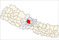
 Kaskikot Location in Nepal | |
| Coordinates: 28°16′19″N 83°54′05″E / 28.27194°N 83.90139°ECoordinates: 28°16′19″N 83°54′05″E / 28.27194°N 83.90139°E | |
| Country |
|
| Zone | Gandaki Zone |
| District | Kaski District |
| Population (2015) | |
| • Total | 27.8 Million |
| Time zone | Nepal Time (UTC+5:45) |
| Website | http://ddckaski.gov.np/ne-vdc-information/ |
Kaskikot (Nepali: कास्कीकोट), commonly known as Kaski, is a ward of Pokhara Lekhnath Metropolitan City. It was previously part of a village development committee in the Kaski District, a region of northern-central Nepal.
Geography

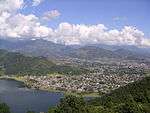
Kaskikot is located in the Annapurna Massif, north of Fewa Lake and 12 km west of Pokhara after Sarangkot. Kaskikot is on the trekking route to the Annapurna region. A mountainside ridge at an altitude of 1,788 m provides panoramic Himalayan views. On the northern side of Kaskikot, Dhawalagiri can be seen in the far west. The Annapurna mountain range is clearly visible on the same side. To the east, the village overlooks the city of Pokhara across Fewa Lake.
Kaskikot shares territory with Sarangkot, Chapakot, Dhikurpokhari, and Hemja.
History
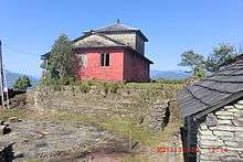
Before the unification of Nepal, there were 24 small principalities in west Nepal, one of which was Kaski. The ruins of the old palace of the rulers of Kaski can still be seen in Kaskikot. During Dashain holidays various cultural events take place there.[1] This historical kingdom was an early homeland of the Shah dynasty. Kulmandan Shah was one of the rulers who established his Kingdom in West Nepal. His descendant Drabya Shah was the first to establish Gorkha, the source of the legendary Gorkha warriors.
Kaskikot Kalika Temple lies in the historical palace at the top of the hill (1700 meters). During nava durga, Dashain and Chaitra Dashain Kaski Guthi Sastha organise worship to goddess Durga Bhawani. According to historical data, Risi Kasyap stayed Tapashya so Kaski was named after him. Many people gather in Kaskikot Temple during Dashain Fulpati and Chaitra Dashain.
Population
At the time of the 1991 Nepal census, Kaskikot had a population of 6,075 persons, residing in 1185 individual households.[1] According to the census of 2011, the population has decreased to 5,892, residing in 1,508 households.[2] Most depend on agriculture and are members of the Brahmin, Chhetri, Thakuri, Magar and Dalits castes. One hundred percent of the inhabitants are Hindu.
Economy
With the Annapurna and Dhaulagiri Himalayas clearly visible to the north, Kaskikot is a tourist destination, and there are hotels and guest houses in Deurali and Maula. A milk collection center is located in Gunte Chour, which supplies milk to Pokhara. There are small industries like poultry farming and handicrafts. General stores provide necessary goods like oil, sugar, and salts to the community.
Kaskikot Women's Financial Organization, founded by Krishna Paudel, has around 1000 members. The Kalika Community Development Organization, located in Guntechour, engages in development work in the village. Numerous organizations and Youths Clubs also organize different cultural and development work around the village.
Village amenities
There are primary schools in every ward. Kalika Higher Secondary School, located at Mandredhunga is the only the Higher education institution teaching up to Class 12. The other Siddha Bahara Lower Secondary School goes up to Class 8. There is also a private school, Shree Bishwajyoti English Boarding School.
There is a general Health Post equipped with primary medicine, which operates a monthly health camp around the village. A few health sub-posts provide free treatment and vaccination to children.
Kaskikot is connected by a number of bus routes. Apart from buses, local agricultural transport jeeps provide a semi-reliable transport service, but they are considered a bit expensive. There are four rough motor roads connecting Kaskikot. A major road connects Kaskikot to Pokhara and Sarangkot, an adventurous trip as the 5 km road climbs to Sarangkot from 700 meters to 1200 meters high. The other road goes from the beach of Fewa Lake and next from the midway of the hill to Gunte Chour and connect Naudanda.
==Important Places in Kaskikot=(POKHARA LAKHANATHA NAGARPALIKA 24)
- Kaskikot Ancient Palace ( Shaktipith: Gupta Kalika Temple)
- Khadgaukot
- Deurali
- Guntechour
- Raikar
- Chilimdanda
- Paharepani (Mandradhunga)
- Kaule
- Pame
- Dhokamukh
- Gairabari
Gallery
 Kaskikot Temple
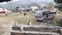
 School at Guntechour, Kaskikot.
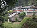 House in Kaskikot
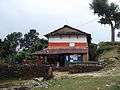 House in Guntechour
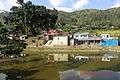 Thuli Pokhari During Winter.
References
- 1 2 "Nepal Census 2001". Nepal's Village Development Committees. Digital Himalaya. Archived from the original on October 12, 2008. Retrieved September 30, 2008.
- ↑ "National Population and Housing Census 2011" (PDF). Central Bureau of Statistics, Nepal. March 2014.
External links
- UN map of the municipalities of Kaski District
- https://www.youtube.com/watch?v=xqzwiInew6Q
- https://www.youtube.com/watch?v=EzvhZ1PPv10
- https://www.youtube.com/watch?v=oj4IFTlmfFI