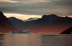
Kaiser Franz Joseph Fjord
| Kaiser Franz Joseph Fjord | |
|---|---|
 Eerie landscape at Kaiser Franz Joseph Fjord | |
 Kaiser Franz Joseph Fjord Location within Greenland | |
| Coordinates | 73°27′N 25°00′W / 73.450°N 25.000°WCoordinates: 73°27′N 25°00′W / 73.450°N 25.000°W |
| Ocean/sea sources | Greenland Sea |
| Basin countries | Greenland |
| Max. length | 190 km (120 mi) |
| Max. width | 25 km (16 mi) |
Kaiser Franz Joseph Fjord (Danish: Kejser Franz Josef Fjord; Greenlandic: Kangerluk Kejser Franz Joseph) is a major fjord system in the NE Greenland National Park area, East Greenland.
Geography
The Kaiser Franz Joseph Fjord has its mouth in the Foster Bay of the Greenland Sea, between Cape Mackenzie at the eastern end of Geographical Society Island and Cape Franklin, the southern end of the mainland's Gauss Peninsula; Bantekoe Island lies in the bay off its mouth. It extends westwards for about 100 km, then at Eleonore Bay in an NNE/SSW direction for about 32 km, bending again westwards at Cape Mohn, the western end of Ymer Island, branching again with the Isfjord extending northwestwards for over 60 km.
Two tributary fjords, the wide Nordfjord —with the large Waltershausen Glacier at its head—and the narrower Geologfjord —with the Nunatak Glacier, branch from the northern side of the fjord, about 70 km from the entrance. The Devil's Castle (Teufelsschloss) is a prominent mountain of reddish rock with a lighter stripe extending diagonally across its face that stands close to the southern side of Cape Petersens, the NW extremity of Ymer Island.[1]
The fjord is bounded by the Suess Land Peninsula and Ymer Island to the South, and by Frænkel Land, Andrée Land and the Gauss Peninsula to the North.[2]
|
History
This fjord was first surveyed and partially explored by the Second German North Polar Expedition 1869–70 and named Kaiser Franz Joseph Fjord for Franz Joseph, Emperor of Austria-Hungary, who had made substantial donations to the expedition.
See also
References
- ↑ Prostar Sailing Directions 2005 Greenland and Iceland Enroute, p. 120
- ↑ "Kejser Franz Josef Fjord". Mapcarta. Retrieved 20 April 2016.
External links
 Media related to Franz Josef Fjord at Wikimedia Commons

