Maniema
| Maniema Province Province du Maniema | |
|---|---|
| Province | |
_-_Maniema.svg.png) | |
| Coordinates: 02°57′S 25°57′E / 2.950°S 25.950°ECoordinates: 02°57′S 25°57′E / 2.950°S 25.950°E | |
| Country |
|
| Capital | Kindu |
| Government | |
| • Governor | Pascal Tutu Salumu |
| Area | |
| • Total | 132,520 km2 (51,170 sq mi) |
| Area rank | 6th |
| Population (2010 est.) | |
| • Total | 2,049,300 |
| • Rank | 18th |
| • Density | 15/km2 (40/sq mi) |
| Official language | French |
| National language | Swahili |
| Website |
gouvernoratmaniema |

Manyema Village in 1876

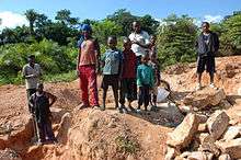
Miners and their children in Kailo Territory, 2007
Maniema is one of 26 provinces of the Democratic Republic of the Congo.[1] Its capital is Kindu.
Toponymy
Henry Morton Stanley explored the area, calling it Manyema.[2]:Vol.Two,96
Geography
Maniema borders the provinces of Kasai-Oriental to the west, Orientale to the north, North Kivu and South Kivu to the east, and Katanga to the south.
Political divisions
Maniema consists of the city of Kindu and seven territories: Punia, Pangi, Lubutu, Kibombo, Kasongo, Kailo and Kabambare. The city of Kindu has the communes of Alungili, Kasuku and Mikelenge
Economy
Mining is the main industry in the province and diamonds, copper, gold and cobalt are mined outside of Kindu.[3]
Kailo Territory is home to open pit wolframite and Cassiterite mines.[4]
Education
See also
References
- ↑ Central Intelligence Agency (2014). "Democratic Republic of the Congo". The World Factbook. Langley, Virginia: Central Intelligence Agency. Retrieved 10 May 2016.
- ↑ Stanley, H.M., 1899, Through the Dark Continent, London: G. Newnes, Vol. One ISBN 0486256677, Vol. Two ISBN 0486256685
- ↑ http://maniemamining.com/
- ↑ "Mining in Kailo". Flickr - Photo Sharing!.
External links
![]() Media related to Maniema at Wikimedia Commons
Media related to Maniema at Wikimedia Commons
- Official website (in French)
This article is issued from
Wikipedia.
The text is licensed under Creative Commons - Attribution - Sharealike.
Additional terms may apply for the media files.