Kagando Hospital
| Kagando Hospital | |
|---|---|
| Geography | |
| Location |
Kagando, Kasese District, Western Region, Uganda |
| Organisation | |
| Care system | Private |
| Hospital type | General |
| Services | |
| Beds | 250 |
| History | |
| Founded | 1965 |
| Links | |
| Other links | Hospitals in Uganda |
Kagando Hospital, also known as Kagando Mission Hospital, is a hospital in the Western Region of Uganda.[1]
Location
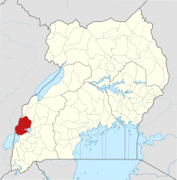
The hospital is located in Kagando Village, in Kasese District, Rwenzururu sub-region, at the foothills of the Rwenzori Mountains, and close to Queen Elizabeth National Park. Its location is approximately 117 kilometres (73 mi), by road, southwest of Fort Portal Regional Referral Hospital.[2] This is about 152 kilometres (94 mi), by road, northwest of Mbarara National Referral Hospital.[3] The coordinates of Kagando Hospital are 0°03'47.0"N, 29°53'53.0"E (Latitude:0.063056; Longitude:29.898069).[4]
Overview
Kagando Hospital is a rural community hospital, owned and administered by Kagando Rural Development Center (KARUDEC), a Christian Missionary NGO that also owns and manages Kagando School of Nursing and Midwifery and other community outreach programs in the area. KARUDEC is affiliated with the Church of Uganda.[5] The hospital has 250 beds and averages about 20,000 annual outpatient visits and about 18,000 annual inpatient admissions. The professional staff includes: 2 surgeons, 2 physicians, one anesthesiologist, one physiotherapist and a number of nurses and midwives.[5]
Every morning at 8 am in the KARUDEC Chapel, there is a service for all doctors, nurses, nursing students and medical students, in which the hospital patients and local issues are prayed for. After the church service, everyone goes to do their work. Kagando hospital is a favorite choice for medical students in the Ugandan medical schools and foreign medical students who may volunteer to spend their elective (part of their training which involves work overseas) at Kagando.[6]
History
The hospital was established in 1965, by the African Inland Missionaries. In the beginning, it treated primarily patients afflicted with leprosy. Today, the specialty wards at the hospital include the following:[6]
- Pediatric Ward
- Male Medical Ward
- Female Medical Ward
- Male Surgical Ward
- Female Surgical Ward
- Maternity Ward
- Leprosy Ward
- Tuberculosis Ward
- Neonatal Unit[7]
Community Outreach
In response to the needs of the community, the hospital established outreach programs, including the following:
- Kagando School of Nursing and Midwifery was established in 1965 to respond to the shortage of nurses and midwives in the community. Today, student capacity of nearly 250 students
- There was a severe outbreak of cholera in 1978, following which, a community-based healthcare project was established, which is involved in malaria control, water supply and sanitation.
- A Functional Adult Literacy Program
- Due to increasing malnutrition in the community, particularly among children, an agricultural extension program was started in 1981. Today, those activities consist of an Agriculture Extension Program, including a KARUDEC Farm on the 35 acres (14 ha) campus
- A Microfinance program
- A kindergarten and elementary school with nearly 700 pupils
- A chaplaincy at the centre of all the programmes. The Kagando Chaplainncy is under the South Rwenzori Diocese of the Church of Uganda
- In 1986 Kagando Hospital (250 beds), and its outreach activities rebranded as Kagando Rural Development Center (KARUDEC), an NGO.
The community in KARUDEC's service area is intimately involved in the NGO's activities. The people in the community are generally poor, with limited means and often with limited formal education. Despite the odds, KARUDEC is slowly making a positive impact.[8]
See also
References
- ↑ Lefanu, James (22 July 2012). "Doctor’s Diary: The Ugandan hospital that urgently needs a mechanical ventilator". The Daily Telegraph. London. Retrieved 4 June 2016.
- ↑ GFC (4 June 2016). "Distance between Kagando Hospital, Bukonjo, Western Region, Uganda and Kabarole Referral Hospital (Buhinga), Fort Portal, Western Region, Uganda". Globefeed.com (GFC). Retrieved 4 June 2016.
- ↑ GFC (4 June 2016). "Distance between Kagando Hospital, Bukonjo, Western Region, Uganda and Mbarara Regional Referral Hospital, Mbarara, Western Region, Uganda". Globefeed.com (GFC). Retrieved 4 June 2016.
- ↑ Google (4 June 2016). "Location of Kagando Hospital, Kasese District, Western Region, Uganda" (Map). Google Maps. Google. Retrieved 4 June 2016.
- 1 2 KAMHF (4 June 2016). "About Kagando Mission Hospital". Dorset, VT: Kagando Mission Hospital Foundation (KAMHF). Retrieved 4 June 2016.
- 1 2 Amber Wilson (2011). "Kagando Hospital, 2011 - Amber Wilson, medical elective". London: Christian Medical Foundation. Retrieved 4 June 2016.
- ↑ Sue Bamford, and Joe Bamford (4 June 2016). "Kagando Mission Hospital Update: Sue & Joe Bamford’s Recent Trip to Uganda". Kagando Mission Hospital Foundation (KMHF). Retrieved 4 June 2016.
- ↑ KMHF (4 June 2016). "Kagando Mission Hospital Programs". Dorset, VT: Kagando Mission Hospital Foundation (KMHF). Retrieved 4 June 2016.
External links
Coordinates: 00°03′47″N 29°53′53″E / 0.06306°N 29.89806°E
