Jyotisar


Jyotisar is a town on the Kurukshetra-Pehowa road, in the Kurukshetra district of Haryana, India. It is at this place where Krishna delivered the Bhagavad Gita to Arjuna to remove his confusion and dilemma and prepared him to face stronger and greater warriors like Bhishma and Karna in the Mahabharata War.
The banyan tree under which the Bhagavad Gita was delivered still stands. [1][2]

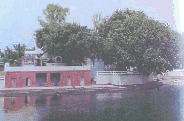
'Jyoti' means light and 'Sar' means the core meaning. Hence the name of place is a reference to the 'core meaning of light' or ultimately of God. It is one of the most revered holy sites of the holy city of Kurukshetra. A Vat (Banyan tree) stands on a raised plinth. Local traditions say that this tree is an offshoot of the holy Banyan tree under which Lord Krishna delivered the sermon of Bhagavad Gita, the doctrine of Karma and Dharma to his wavering friend Arjuna. It is here that He showed his Virat rupa (Universal form).
A marble chariot depicting Krishna delivering the sermon to Arjuna marks the site of the Srimad Bhagwad Gita. In one secluded section of this center, an old Shiva temple can also be seen. Hundreds of years ago, a holy water tank was present here and it can still be seen in the rainy season. The Kurukshetra Development Board has renovated the site in recent times. A mango shaped lake has been constructed here with covered bathing ghats for ladies. Cement parapets and enclosures have been built for protection. A light and music show is organized by the tourism department at the site, on a regular basis, which recreates episodes from the epic Mahabharata. A restaurant and accommodation wing for pilgrims have been built and the entire area has been landscaped with flowering bushes and eucalyptus trees.
Kalpana Chawla Planetarium
The government of Haryana has built the Kalpana Chawla Planetarium in Jyotisar.[3]
See also
- Shrikrishna Museum
- Kurukshetra Panorama and Science Centre
- Jyotisar Light and Sound Show
- Dharohar Museum
Notes
- ↑ Jyotisar Kurukshetra district website.
- ↑ "Jyotisar". Haryana Tourism Corporation Limited. Retrieved 2014-08-08.
- ↑ 29° 57' 42.42" N 76° 46' 16.12" E
External links
Coordinates: 29°57′40″N 76°46′08″E / 29.961°N 76.769°E