Jumgal District
| Jumgal | |
|---|---|
| Raion | |
 | |
| Country | Kyrgyzstan |
| Region | Naryn Region |
| Area | |
| • Total | 4,803 km2 (1,854 sq mi) |
| Population (2009) | |
| • Total | 40,718 |
| • Density | 8.5/km2 (22/sq mi) |
| Time zone | GMT +5 (UTC+5) |
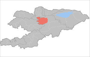
Jumgal is a raion (district) of Naryn Region in central Kyrgyzstan. The capital lies at Chaek.[1] Its area is 4,803 square kilometres (1,854 sq mi), and its resident population was 40,718 in 2009.[2] The river Jumgal is situated in this district,[3] it is a tributary of Kökömeren River, the latter is tributary to Naryn river.
Populated places
In total, Jumgal District include 13 rural communities (aiyl okmotus). Each rural community includes one or several villages. The rural communities in Jumgal District and settlements are as follows:[4][5]
- Ming-Kush rural community (center - Min-Kush, and also village Kyzyl-Seok)
- Bash-Kuugandy aiyl okmotu (center - village Bash-Kuugandy)
- Jany-Aryk aiyl okmotu (center - village Jany-Aryk, and also villages Bazar-Turuk, Kyzart, Kyzyl-Emgek)
- Jumgal aiyl okmotu (center - village Jumgal, and also village Lama)
- Kabak aiyl okmotu (center - village Tabylgyty, and also villages Aral, Keng-Suu, Kotur-Suu, Kyzyl-Korgon, Sary-Bulung, Tabylgy)
- Kök-Oy aiyl okmotu (center - village Kök-Oy, and also village Kichi-Aral)
- Bayzak aiyl okmotu (center - village Bayzak)
- Kuyruchuk aiyl okmotu (center - village Kuyruchuk)
- Chong-Dobo aiyl okmotu (center - village Chong-Döbö)
- Tyugol-Say aiyl okmotu (center - village Tyugol-Say, and also Epkin)
- Suyumbay aiyl okmotu (center - village Tash-Dobo)
- Chaek aiyl okmotu (center - village Chaek, and also villages Ak-Tatyr, Besh-Terek)
- Kyzyl-Jyldyz aiyl okmotu (center - village Kyzyl-Jyldyz)
References
- ↑ Enrin.grida.no Archived 2009-08-02 at the Wayback Machine.
- ↑ "2009 population census of the Kyrgyz Republic: Naryn Region" (PDF). Archived from the original on 25 October 2012. Retrieved 2016-06-15.
- ↑ Svetlana Jacquesson, « Au cœur du Tian Chan : histoire et devenir de la transhumance au Kirghizstan », Cahiers d’Asie centrale [En ligne], 11/12 | 2004, mis en ligne le 23 juin 2009, Consulté le 19 janvier 2010. URL : http://asiecentrale.revues.org/index700.html
- ↑ List of Rural Communities of Kyrgyzstan
- ↑ 2012 Law on the transformation of individual urban settlements of the Kyrgyz Republic and relating them to the category of village or city
| Bishkek City |  | |
|---|---|---|
| Osh City |
| |
| Batken Region | ||
| Chuy Region | ||
| Issyk-Kul Region | ||
| Jalal-Abad Region | ||
| Naryn Region | ||
| Osh Region | ||
| Talas Region | ||
Coordinates: 41°55′N 74°30′E / 41.917°N 74.500°E
This article is issued from
Wikipedia.
The text is licensed under Creative Commons - Attribution - Sharealike.
Additional terms may apply for the media files.