Julianadorp
| Julianadorp | |||
|---|---|---|---|
| Town | |||
|
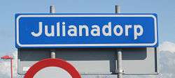
Town sign | |||
| |||
 | |||
 The town centre (dark green) and the statistical district (light green) of Julianadorp in the municipality of Den Helder. | |||
| Coordinates: 52°53′N 4°44′E / 52.883°N 4.733°ECoordinates: 52°53′N 4°44′E / 52.883°N 4.733°E | |||
| Country | Netherlands | ||
| Province | Noord-Holland | ||
| Municipality | Den Helder | ||
| Population (1 January 2006) | |||
| • Total | 13,925 | ||
| Time zone | CET (UTC+1) | ||
| • Summer (DST) | CEST (UTC+2) | ||
| Postal code | 1787 - 1788 | ||
| Dialing code | 0223 | ||
Julianadorp is a town in the Dutch province of North Holland. It is a part of the municipality of Den Helder, and lies about 6 km south of Den Helder.
It was formed in 1909, and named after Princess Juliana who was born that same year. Mr. Loopuyt asked Queen Wilhelmina in October 1909 for permission to name the village after the newborn princess. Permission was granted.
During World War II, Julianadorp changed its name to Loopuytdorp, because the Germans were not pleased with the link to the Dutch Royal family. After the war, the village got its original name back.
In 2001, the town of Julianadorp had 14,359 inhabitants. The built-up area of the town was 3.12 km², and contained 5,280 residences.[1] The statistical district "Julianadorp", which covers the village and the surrounding countryside, has a population of around 14,710.[2]


