Jhunjhunu district
| Jhunjhunu (jai singh) district | |
|---|---|
| District of Rajasthan | |
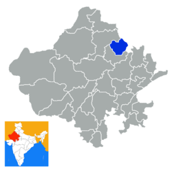 Location of Jhunjhunu (jai singh) district in Rajasthan | |
| Country | India |
| State | Rajasthan |
| Administrative division | Jaipur Division |
| Headquarters | Jhunjhunu |
| Tehsils | 1. Jhunjhunu, 2. Chirawa, 3. Buhana, 4. Khetri, 5. Nawalgarh, 6. Udaipurwati 7.Malsisar 8. Surajgarh |
| Government | |
| • Lok Sabha constituencies | Jhunjhunu[1] |
| • Assembly seats | 1. Jhunjhunu, 2. Mandwa, 3. Pilani, 4. Nawalgarh, 5. Khetri, 6. Udaipurwati, 7. Surajgarh[2] |
| Area | |
| • Total | 5,926 km2 (2,288 sq mi) |
| Population (2011) | |
| • Total | 2,137,045[3] |
| • Urban | 22.89 percent |
| Demographics | |
| • Literacy | 74.72 |
| • Sex ratio | 950 |
| Major highways | State Highway 8 |
| Coordinates | 75°01′N 76°04′E / 75.02°N 76.06°E - 27°23′N 28°19′E / 27.38°N 28.31°E |
| Website | Official website |
Jhunjhunu district is a district of the Indian state Rajasthan in western India. The town Jhunjhunu is the district headquarters. Jhunjhunu is the only district in India which has contributed maximum number of soldiers in Indian Army. As an average every house has one or more soldier serving in Indian Army.[4]
History
Jhunjhunu district is part of Shekhawati Region. Jhunjhunu was founded and ruled by the Kaimkhani Nawabs till 1730. Nawab Rooh Ullah Khan was the last Nawab of Jhunjhunu. The Nawabs ruled over Jhunjhunu for 280 years. Rooh Ullah Khan had imposed great faith in Shardul Singh and he acted as his Diwan. Shardul Singh was a bold and efficient administrator but he deceived to Nawab. He occupied Jhunjhunu after the death of Rohilla Khan in 1730 A.D.
It was by dint of his subtle political demeanour that Maharao Shardul Singh occupied Jhunjhunu & ruled over it for 12 years. After his death the estate was divided equally among his five sons. Their descendants continued to rule over it till Indian Independence in 1947. Shardul Singh's religious belief was instrumental in him having built many temples such as Kalyan Ji Mandir & Gopinath Ji Ka mandir at Jhunjhunu. To commemorate Maharao Shardul Singh, his sons made a monumental dome at Parasrampura ordorned with fresco paintings.
District Location
The district falls within Shekhawati region, and is bounded on the northeast and east by Haryana state, on the southeast, south, and southwest by Sikar District, and on the northwest and north by Churu District.
Demographics
According to the 2011 census Jhunjhunu district has a population of 2,139,658,[5] roughly equal to the nation of Namibia[6] or the US state of New Mexico.[7] This gives it a ranking of 214th in India (out of a total of 640).[5] The district has a population density of 361 inhabitants per square kilometre (930/sq mi).[5] Its population growth rate over the decade 2001-2011 was 11.81%.[5] Jhunjhunun has a sex ratio of 950 females for every 1000 males,[5] and a literacy rate of 74.72%.[5]
Notable people
The Pasaris, Piramals, Chandaks and The Birla family, four families of prominent Indian industrialists, hail from the district. Former Central Minister Late Sis Ram Ola was also from the district.
Place of interest
- Ramakrishna Mission in the Khetri town of the district.
- Dhosi Hill
- Rani Sati Temple Jhunjhunu
- Khetri Mahal
- Netji Dada Temple, in the village of Khudania
- Shree Jhujhar ji Temple, Dhanuri
- Bhopal Garh Fort in Khetri
- Alsisar Mahal in Alsisar
- Sculpture of Jujhar singh
- Havelis in Nawalgarh
- GogaMedi at Sotwara
- Science park in Nawalgarh
- Temple of Ramdevji in Nawalgarh (First one is in Ramdevra)
- Tibrewala and Modi Haveli
- Bissau Fort in Bissau
- Surajgarh Fort in Surajgarh
- Bissau Mahal in Jhunjhunu
- Shyamgarh Fort in Jhunjhunu
- Bishangarh Fort in Tamkor
Industries
Famous copper mines are situated in the Khetri tehsil of the district. The Khetri Copper Complex of Hindustan Copper Limited is situated at distance of 10 km from the Khetri town. It is the largest Copper mines in India. It also has by-products i.e. Sulphuric Acid, Fertilizer etc.
Education
- Dalmia Vidya Mandir Chirawa
- K R Memorial Sr. Sec School, Pilani
- BITS Pilani
- Delhi Public School Jhunjhunu
- Shri Jagdish Prasad Jhabarmal Tibrewala University.
- CSIR-CEERI, PILANI
- Dalmia Hr. Sec. School, Chirawa
- Jhunjhunu Academy School
- Shekhawati Public School Hetamsar
- Keystone Group of Institutions, Surajgarh, Jhunjhunu
- Jagdamba public senior sec. school, kalota, jhunjhunu
- Tagore public senior sec. school, kalota, jhunjhunu
- Biswambhar Lal Senior Sec. School, Bagar, jhunjhunu
- Singhania University Pacheri
- MODERN SURYA PUBLIC SCHOOL,
AGARSEN CIRCLE, JHUNJHUNU
- smt.manbhari devi t.t. college chanana, jhunjhunu
- Smt.Manbhari Devi (P.G.) college chanana, Jhunjhunu
Gallery
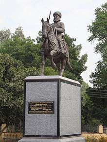 Statue of Jujhar Singh Nehra, in Jhunjhunu town
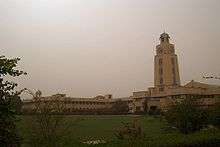 Clock tower, BITS Pilani, Campus
References
- ↑ "Parliamentary Constituencies of Rajasthan" (PDF). http://164.100.9.199/home.html. 2012. Retrieved 2012-02-23. External link in
|publisher=(help) - ↑ "Assembly Constituencies of Jhunjhunu district" (PDF). gisserver1.nic.in. 2012. Retrieved 2012-02-23.
- ↑ Jhunjhunu district (2011 Census of India)
- ↑ "Jhunjhunu has maximum number of martyrs in the country". Etv.
- 1 2 3 4 5 6 "District Census 2011". Census2011.co.in. 2011. Retrieved 2011-09-30.
- ↑ US Directorate of Intelligence. "Country Comparison:Population". Retrieved 2011-10-01.
Namibia 2,147,585
- ↑ "2010 Resident Population Data". U. S. Census Bureau. Archived from the original on 2013-10-19. Retrieved 2011-09-30.
New Mexico - 2,059,179
External links
Adjacent places of Jhunjhunu district | |||||||||||||||||
|---|---|---|---|---|---|---|---|---|---|---|---|---|---|---|---|---|---|
 |
| | |||||||||||||||
| Outline |  | ||||||||||||||
|---|---|---|---|---|---|---|---|---|---|---|---|---|---|---|---|
| Governance | |||||||||||||||
| Divisions and Districts |
| ||||||||||||||
| Major cities | |||||||||||||||
| Related templates |
| ||||||||||||||