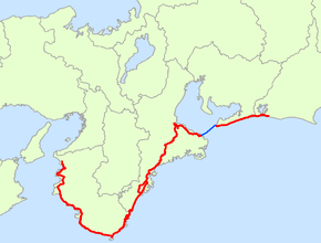
Japan National Route 42
| |
|---|---|
| 国道42号 (Kokudō yonjūni-gō) | |
 | |
| Route information | |
| Length: | 504.6 km (313.5 mi) |
| Existed: | 1945 – present |
| Major junctions | |
| East end: | Hamamatsu |
| West end: | Wakayama |
| Highway system | |
|
National highways of Japan Expressways of Japan | |
National Route 42, also called Kumano Kaido or Tropical Route is a national highway connecting Hamamatsu, Shizuoka and Wakayama, Wakayama in Japan. Part of the route requires crossing Ise Bay on the Ise-wan Ferry.[1][2]
It is the 8th longest national highway in Japan.
Route Data
- Length: 504.6 km (313.5 mi)
- Origin: Hamamatsu (originates at junction with Route 1)
- Terminus: Wakayama city
- Major cities: Tahara, Toba, Ise, Matsusaka, Owase, Kumano, Shingū, Tanabe, and Gobō
Passes through
- Shingū • Nachikatsuura • Taiji • Kushimoto • Susami • Shirahama • Minabe • Inami • Gobō • Hidaka • Yura • Hirogawa • Yuasa • Aridagawa • Arida • Kainan • Wakayama
Intersects with
- Shizuoka Prefecture
- Aichi Prefecture
- Mie Prefecture
- Route 167
- Route 23
- Route 166
- Ise Expressway
- Route 368
- Kisei Expressway
- Route 260
- Route 425
- Route 311
- Route 309
- Route 311
- Wakayama Prefecture
- Route 168
- Route 371
- Route 311
- Hanwa Expressway
- Route 424
- Route 425
- Yuasa-Gobō Bypass
- Route 480
- Route 24
- Route 26
References
This article is issued from
Wikipedia.
The text is licensed under Creative Commons - Attribution - Sharealike.
Additional terms may apply for the media files.
