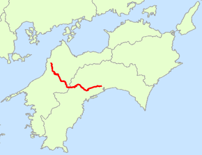
Japan National Route 33
| |
|---|---|
| 国道33号 (Kokudō Sanjūsan-gō) | |
 | |
| Route information | |
| Length: | 122.9 km (76.4 mi) |
| Highway system | |
|
National highways of Japan Expressways of Japan | |
National Route 33 (国道33号 Kokudō Sanjūsan-gō), also known as the Tosa Kaidō, is a Japanese highway on the island of Shikoku. It originates at the intersection of Route 32 and other arteries in the city of Kōchi (capital of Kōchi Prefecture) and terminates in the city of Matsuyama (capital of Ehime Prefecture), where it meets Route 11 and other national highways. Its history dates to the year 662. [1]
Route Data
- Length: 122.9 km (76.4 mi)
- Origin: Kōchi (originates at the terminus of Routes 32 and 55 and the origin of Routes 55, 194, 195, 197 and 493)
- Terminus: Matsuyama (ends at the terminus of Routes 11 and 56)
- Major cities: Niyodogawa, Kumakōgen
History
- 1952-12-04 - First Class National Highway 33 (from Kōchi to Matsuyama)
- 1965-04-01 - General National Highway 33 (from Kōchi to Matsuyama)
References
- ↑ 一般国道33号 (in Japanese). Ministry of Land, Infrastructure, Transport and Tourism, Shikoku Regional Development Bureau. Archived from the original on 2011-07-21. Retrieved 2010-12-04.
| Wikimedia Commons has media related to Route 33 (Japan). |
This article is issued from
Wikipedia.
The text is licensed under Creative Commons - Attribution - Sharealike.
Additional terms may apply for the media files.
