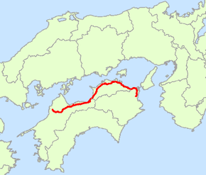
Japan National Route 11
| |
|---|---|
| 国道11号 (Kokudō Jūichi-gō) | |
 | |
| Route information | |
| Length: | 239.4 km (148.8 mi) |
| Highway system | |
|
National highways of Japan Expressways of Japan | |
National Route 11 is a Japanese highway on the island of Shikoku. The most important artery in Shikoku, it originates at the intersection with Routes 28, 55 and 195 in the prefectural capital of Tokushima (Tokushima Prefecture) and terminates at the intersection with Routes 33, 56, 317, 379, 440 and 494 in Matsuyama (the capital of Ehime Prefecture). Between the terminals, it passes through Naruto (Tokushima Prefecture) and Takamatsu (the capital of Kagawa Prefecture), as well as other regional population centers. Route 11 measures 239.4 km in length.[1]
Route data
- Length: 239.4 km (148.8 mi)
- Origin: Tokushima (originates at junction with Routes 28, 55 and 195)
- Terminus: Matsuyama, Ehime (ends at Junction with Routes 33, 56, 317, 379, 440 and 494)
- Major cities: Naruto, Takamatsu, Sakaide, Marugame, Shikokuchuo, Niihama, Saijo, Toon
History
- 1952-12-04 - First Class National Highway 11 (from Tokushima to Matsuyama)
- 1965-04-01 - General National Highway 11 (from Tokushima to Matsuyama)
Overlapping sections
- From Tokushima (Kachidoki-bashi intersection) to Matsushige: Route 28
- From Naruto (Naruto IC intersection) to Higashikagawa (Takoda intersection): Route 377
- In Takamatsu, from Bancho intersection to Nakajincho intersection: Routes 30 and 436
References
- ↑ 一般国道11号 (in Japanese). Ministry of Land, Infrastructure, Transport and Tourism. Shikoku Regional Development Bureau. Archived from the original on 2010-08-03. Retrieved 2010-12-04.
| Wikimedia Commons has media related to Route 11 (Japan). |
This article is issued from
Wikipedia.
The text is licensed under Creative Commons - Attribution - Sharealike.
Additional terms may apply for the media files.
