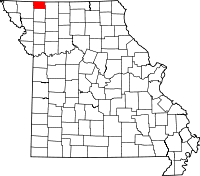
Isadora, Missouri
| Isadora, Missouri | |
|---|---|
| Unincorporated community | |
 Isadora, Missouri | |
| Coordinates: 40°31′33″N 94°31′04″W / 40.52583°N 94.51778°WCoordinates: 40°31′33″N 94°31′04″W / 40.52583°N 94.51778°W | |
| Country | United States |
| State | Missouri |
| County | Worth |
| Elevation | 974 ft (297 m) |
| Time zone | Central (CST) (UTC-6) |
| • Summer (DST) | CDT (UTC-5) |
| Area code(s) | 660 |
| GNIS feature ID | 730122[1] |
Isadora is an unincorporated community in Worth County, Missouri, United States. Isadora is northwest of Grant City and east of Sheridan.
Isadora was platted in 1863.[2] A post office called Isadora was established in 1866, and remained in operation until 1951.[3] According to tradition, the community was named after the wife of a pioneer man who paid a visit to the area.[2]
References
- ↑ "US Board on Geographic Names". United States Geological Survey. 2007-10-25. Retrieved 2008-01-31.
- 1 2 "Worth County Place Names, 1928–1945". The State Historical Society of Missouri. Archived from the original on June 24, 2016. Retrieved January 3, 2017.
- ↑ "Post Offices". Jim Forte Postal History. Retrieved 3 January 2017.
This article is issued from
Wikipedia.
The text is licensed under Creative Commons - Attribution - Sharealike.
Additional terms may apply for the media files.
