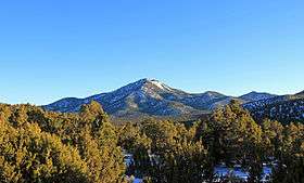
Iron Mountain (Utah)
| Iron Mountain | |
|---|---|
 Iron Mountain viewed from the southwest | |
| Highest point | |
| Elevation | 7,831 ft (2,387 m) NGVD 29[1] |
| Prominence | 1,421 ft (433 m) [1] |
| Coordinates | 37°38′40″N 113°22′27″W / 37.6444207°N 113.3741228°WCoordinates: 37°38′40″N 113°22′27″W / 37.6444207°N 113.3741228°W [2] |
| Geography | |
 Iron Mountain Location in Utah | |
| Location | Iron County, Utah, U.S. |
| Topo map | USGS Desert Mound |
Iron Mountain, in southwestern Utah, United States is the namesake of Iron County. Its summit is at 7,815 feet (2,382 m)[1] It has a long history of iron mining, in the form of magnetite and hematite. Mining at this site goes back to Brigham Young and Mormon pioneers in the 1850s.[3] The early history of this mining can be seen at Iron Mission State Park in nearby Cedar City, Utah. It is one of three major peaks in the Iron Mountain Mining District.
References
- 1 2 3 "Iron Mountain UT". ListsOfJohn.com. Retrieved 2016-04-19.
- ↑ "Iron Mountain". Geographic Names Information System. United States Geological Survey. Retrieved 2016-04-19.
- ↑ "Frontier Homestead State Park Museum". Utah State Parks. Archived from the original on 2009-08-27.
External links
![]() Media related to Iron Mountain (Utah) at Wikimedia Commons
Media related to Iron Mountain (Utah) at Wikimedia Commons
This article is issued from
Wikipedia.
The text is licensed under Creative Commons - Attribution - Sharealike.
Additional terms may apply for the media files.