Ikema Island
| Native name: Ikema-jima (池間島) | |
|---|---|
|
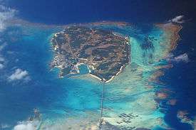
Aerial view of Ikema-jima from southeast | |
| Geography | |
| Location | Okinawa Prefecture |
| Coordinates | 24°55′N 125°15′E / 24.917°N 125.250°E |
| Archipelago | Miyako Islands |
| Major islands | Okinawa, Miyako |
| Area | 2.8 km2 (1.1 sq mi) |
| Highest elevation | 28 m (92 ft) |
| Highest point | Unknown |
| Administration | |
|
Japan | |
| Demographics | |
| Population | 801 (2002) |
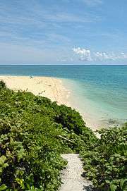
Ikema Island (池間島 Ikema-jima, Miyako: Ikyama (イキャマ)), is located to the north of the Miyako Island in Okinawa Prefecture, Japan. The surface area is 2.6 km². The island is connected with Miyako Island with a 1,592-metre-long (5,223 ft) bridge. There is a pond in the centre of the island. To the north-east is the Ikema-jima Block Beach (池間島ブロックビーチ).

Ikemajima Block Beach
See also
This article is issued from
Wikipedia.
The text is licensed under Creative Commons - Attribution - Sharealike.
Additional terms may apply for the media files.
