Hurricane Katia
| Category 4 major hurricane (SSHWS/NWS) | |
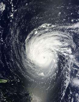
 Hurricane Katia intensifying to the northeast of the Lesser Antilles on September 4 | |
| Formed | August 29, 2011 |
|---|---|
| Dissipated | September 13, 2011 |
| (Extratropical after September 10) | |
| Highest winds |
1-minute sustained: 140 mph (220 km/h) |
| Lowest pressure | 942 mbar (hPa); 27.82 inHg |
| Fatalities | 3 direct, 1 indirect |
| Damage | ~ $157 million (2011 USD) |
| Areas affected | Lesser Antilles, East Coast of the United States, Europe |
| Part of the 2011 Atlantic hurricane season | |
Hurricane Katia was a classic Cape Verde hurricane that had substantial impact across Europe as a post-tropical cyclone. The eleventh named storm, second hurricane, and second major hurricane of the active 2011 Atlantic hurricane season, Katia originated as a tropical depression from a tropical wave over the eastern Atlantic on August 29. It intensified into a tropical storm the following day and further developed into a hurricane by September 1, although unfavorable atmospheric conditions hindered strengthening thereafter. As the storm began to recurve over the western Atlantic, a more hospitable regime allowed Katia to become a major hurricane by September 5 and peak as a Category 4 hurricane with winds of 140 mph (220 km/h) that afternoon. Internal core processes, increased wind shear, an impinging cold front, and increasingly cool ocean temperatures all prompted the cyclone to weaken almost immediately after peak, and Katia ultimately transitioned into an extratropical cyclone on September 10.
Although Katia passed well north of the Lesser Antilles, a yellow alert was hoisted for Guadeloupe to notify residents of dangerous seas. Strong rip currents along the East Coast of the United States led to the deaths of two swimmers. After losing its tropical characteristics, Katia prompted the issuance of numerous warnings across Europe. Hurricane-force winds impacted numerous locations, downing trees, toppling power poles, and leaving thousands without electricity. The storm was responsible for two deaths in the United Kingdom: one when a tree fell on a vehicle in County Durham, and another during a multi-car accident on the M54 motorway resulting from adverse weather conditions. The post-tropical cyclone caused approximately £100m ($157 million, 2011 USD) in damage in the United Kingdom alone.
Meteorological history

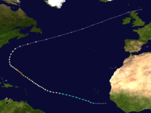
On August 27, the National Hurricane Center (NHC) began monitoring a large mass of convection associated with a tropical wave just off the western coast of Africa.[1] An area of low pressure formed in association with the disturbance the following day,[2] gaining sufficient organization to be declared a tropical depression by 06:00 UTC on August 29 approximately 430 miles (690 km) southwest of the southernmost Cabo Verde Islands.[3] The depression initially struggled upon designation, with its well-defined center displaced near the northeastern edge of the storm's convection as a result of strong east-northeasterly wind shear.[4] By 00:00 UTC on August 30, however, an increase in the cyclone's convective organization marked its intensification into Tropical Storm Katia.[3][5]
Katia tracked west-northwestward for several days, steered by an expansive mid-level ridge to the cyclone's north. The strong upper-level winds that were affecting the cyclone gradually slackened, allowing for the expansion of a central dense overcast, the formation of a large curved band in the southern semicircle, and development of a banding eye on microwave imagery.[6] Satellite intensity estimates increased accordingly, prompting the NHC to upgrade Katia to hurricane intensity at 00:00 UTC on September 1, while the storm was situated about 1,350 miles (2,175 km) east of the Leeward Islands.[3] Although conditions were forecast to remain conducive for further intensification,[6] water vapor satellite and microwave imagery indicated that mid-level dry air began eroding eyewall convection immediately after the storm's upgrade, and upper-level winds eventually became less favorable as Katia approached a sharp upper-level trough. As a result, the storm maintained its status as a minimal hurricane for almost three days, with only a partial eyewall or banding-eye feature appearing on satellite.[3]

Early on September 4, the hurricane moved beneath a large upper-level anticyclone which provided a reprieve from the strong southwesterly wind shear. Although its convective organization had yet to become fully symmetrical, an eye became increasingly apparent on infrared imagery. The center moved very near the National Oceanic and Atmospheric Administration's buoy 41044—which registered a maximum sustained wind of 90 mph (145 km/h) and a maximum wind gust of 108 mph (174 km/h)—around 12:00 UTC, indicating that Katia had intensified into a Category 2 hurricane.[3][7] Although an eyewall replacement cycle briefly caused the storm's convective pattern to deteriorate,[8][9] Katia attained major hurricane status—a Category 3 or higher on the Saffir–Simpson hurricane wind scale—by 12:00 UTC on September 5. Twelve hours later, the cyclone further intensified into a Category 4 hurricane and attained peak winds of 140 mph (220 km/h) and a minimum barometric pressure of 942 mbar (hPa; 27.82 inHg) as its eye warmed, deep convection became much more symmetric about the center, and upper-level outflow expanded.[3][10]
Almost immediately after attaining peak intensity, Katia began to rapidly weaken as a second eyewall replacement cycle began; it was quickly stunted as dry air wrapped into the western portion of the circulation and northwesterly wind shear increased.[11] The inner core process was completed by early on September 7, allowing Katia to level off in intensity as a Category 1 hurricane for several days. Increasing southwesterly flow resultant from an upper-level trough pushing eastward across the United States caused Katia to slow in forward motion and recurve northeast or east-northeast through September 9. The hurricane re-accelerated late that day, eventually bringing Katia over ocean temperatures near 22 °C (72 °F).[3] Deep convection in association with the storm decreased and its circulation merged with a frontal system,[12] indicating that Katia had completed transition into an extratropical cyclone by 12:00 UTC on September 10 while located about 290 miles (465 km) south-southeast of Cape Race, Newfoundland. Increasing baroclinic energy fueled the powerful extratropical low,[12] which skirted the northern coast of Scotland on September 12, before being absorbed by a larger extratropical system over the North Sea on the following day.[3]
Preparations and impact
Lesser Antilles and United States
.jpg)
Although Katia passed well northeast of the Lesser Antilles, a yellow alert was hoisted in Guadeloupe for the potential of 3–5 meter (10–16 ft) swells.[13] Antigua and Barbuda recorded 21.59 millimeters (0.85 in) of rainfall between September 6 and September 7 from an outer band.[14]
On September 4, the NHC noted that large swells likely to cause life-threatening rip current conditions were expected to impact the East Coast of the United States over subsequent days.[15] The increased surf resulted in the death of a swimmer in Ormond Beach, Florida the following day,[16] and a second death off Monhegan, Maine on September 11.[17]
Europe
After transitioning into a post-tropical cyclone, Katia moved quickly across the North Atlantic and toward Europe, prompting the Met Office to begin warnings citizens for potential impacts over subsequent days on September 9. Three days later, the organization raised a yellow severe weather alert for all of Ireland and most of the United Kingdom, with a more severe amber alert hoisted across Northern Ireland, the northernmost United Kingdom, and southern Scotland; both alerts warned of the potential for gale-force winds.[18] Concurrently, the Met Éireann outlined an extreme weather warning across Ireland, alerting residents to the potential for 130 km/h (80 mph) winds, downed trees, damaged buildings, and flooding.[19] Irish ferries cancelled a number of its sails between Dublin and Holyhead.[20] The Swedish Meteorological and Hydrological Institute warned of gale-force winds along the coastline of Sweden, although a brunt of the rainfall was expected in neighboring Norway.[21]

A maximum wind gust of 158 km/h (98 mph) was recorded on Cairn Gorm, Scotland as Katia impacted the region, with a peak gust of 130 km/h (81 mph) observed at a non-mountain station in Capel Curig, Wales;[18] these observations marked the strongest impact from a tropical cyclone since Hurricane Lili in 1996.[22] Waves up to 15 meters (49 ft) battered the western coastline of Ireland, and fallen power lines temporarily disrupted dart services. Approximately 4,000 households were left without power across the country.[23] A catering marquee was blown into the air on a set for the television series Game of Thrones, causing one injury.[24] In County Durham, United Kingdom, a man was killed after a tree fell on the minivan he was driving; the passenger sustained non-life-threatening injuries. A second driver was indirectly killed on the M54 motorway after hazardous weather caused a multi-car accident.[3] Farther south in Bradford, an 11-year-old boy was injured after he was hit by a portion of a roof blown off a garage. Downed power poles set several fields on fire.[25] The second stage of the Tour of Britain was forcefully canceled after strong winds littered the cycle route with debris.[26] Following the storm, damage estimates in the United Kingdom alone topped £100m ($157 million 2011 USD).[27] The remnants of Katia produced damage as far east as Russia. In St. Petersburg, wind gusts up to 45 mph (75 km/h) damaged buildings and left roughly 1,500 residents without power.[28][29] In Estonia, the storm cut off power to approximately 940 households, particularly affecting the island of Hiiumaa and Harju County, with strong winds in coastal areas gusting up to 90 km/h (55 mph).[30]
See also
References
- ↑ Robbie J. Berg (August 27, 2011). "Tropical Weather Outlook" (TXT). National Hurricane Center. Retrieved October 7, 2016.
- ↑ Todd B. Kimberlain; Eric S. Blake (August 28, 2011). "Tropical Weather Outlook" (TXT). National Hurricane Center. Retrieved October 7, 2016.
- 1 2 3 4 5 6 7 8 9 Stacy R. Stewart (January 16, 2012). Tropical Cyclone Report: Hurricane Katia (PDF) (Report). National Hurricane Center. Retrieved October 7, 2016.
- ↑ Richard J. Pasch (August 29, 2011). Tropical Depression Twelve Discussion Number 3 (Report). National Hurricane Center. Retrieved October 7, 2016.
- ↑ Michael J. Brennan (August 30, 2011). Tropical Storm Katia Discussion Number 5 (Report). National Hurricane Center. Retrieved October 7, 2016.
- 1 2 Daniel P. Brown (September 1, 2011). Hurricane Katia Discussion Number 12 (Report). National Hurricane Center. Retrieved October 7, 2016.
- ↑ Robbie J. Berg (September 4, 2016). Hurricane Katia Discussion Number 26 (Report). National Hurricane Center. Retrieved October 8, 2016.
- ↑ Todd B. Kimberlain (September 5, 2011). Hurricane Katia Discussion Number 29 (Report). National Hurricane Center. Retrieved October 7, 2016.
- ↑ Robbie J. Berg (September 5, 2011). Hurricane Katia Discussion Number 30 (Report). National Hurricane Center. Retrieved October 7, 2016.
- ↑ John P. Cangialosi (September 5, 2011). Hurricane Katia Discussion Number 32 (Report). National Hurricane Center. Retrieved October 7, 2016.
- ↑ Todd B. Kimberlain; Richard J. Pasch (September 5, 2011). Hurricane Katia Discussion Number 37 (Report). National Hurricane Center. Retrieved October 7, 2016.
- 1 2 Stacy R. Stewart (September 10, 2011). Post-Tropical Cyclone Katia Discussion Number 50 (Report). National Hurricane Center. Retrieved October 7, 2016.
- ↑ "La houle cyclonique de Katia nous met en vigilance jaune" (in French). September 2, 2011. Retrieved October 13, 2016. – via France-Antilles (subscription required)
- ↑ The Atlantic Hurricane Season Summary – 2011 Special Focus on Antigua and Barbuda (PDF) (Report). Antigua and Barbuda Meteorological Services. April 8, 2012. Retrieved October 14, 2016.
- ↑ Robbie J. Berg (September 4, 2011). Hurricane Katia Public Advisory Number 27 (Report). National Hurricane Center. Retrieved October 13, 2016.
- ↑ Saul Saenz (September 4, 2011). "Tampa man killed while swimming at Ormond Beach". Bay News 9. Retrieved October 13, 2016.
- ↑ Abigail Curtis (September 11, 2011). "Search suspended for man swept to sea off Monhegan Island". Bangor Daily News. Retrieved October 13, 2016.
- 1 2 Post-tropical storm Katia – September 2011 (Report). Met Office. September 30, 2016. Retrieved October 15, 2016.
- ↑ Cathal Dervan (September 12, 2011). "Warnings issued as Hurricane Katia batters Ireland en route to Scotland". Irish Central. Retrieved October 15, 2016.
- ↑ "Storm force winds expected over Ireland". Raidió Teilifís Éireann. September 12, 2011. Retrieved October 15, 2016.
- ↑ "Tropical hurricane heading for Sweden". The Local. September 11, 2011. Retrieved October 15, 2016.
- ↑ Brett Israel (September 12, 2011). "How Often Does Britain Get Hit by Hurricanes?". Live Science. Retrieved October 15, 2016.
- ↑ "Thousands left without power as Hurricane Katia hits Ireland". TheJournal.ie. September 12, 2011. Retrieved October 15, 2011.
- ↑ "Northern Ireland still being hit by Hurricane Katia". BBC News. September 13, 2011. Retrieved October 15, 2016.
- ↑ "Hurricane Katia brings death and chaos to UK". EveningStandard. September 13, 2011. Retrieved October 15, 2016.
- ↑ "Tour of Britain: Second stage cancelled because of high winds". BBC News. September 12, 2011. Retrieved October 15, 2016.
- ↑ Emily Allen (September 14, 2011). "Damage from Hurricane Katia will cost UK £100M after high winds battered Britain". Daily Mail. Retrieved October 15, 2016.
- ↑ Петербург оправляется от урагана: повалены десятки деревьев, повреждены автомобили (in Russian). Российское информационное агентство. September 15, 2011. Retrieved October 15, 2016.
- ↑ Ослабевший ураган "Катя" добрался до Санкт-Петербурга (in Russian). KM Онлайн. September 15, 2011. Retrieved October 15, 2016.
- ↑ Ingrid Teesalu (September 14, 2011). "Gales Leave 900 Households Blacked Out". err.ee. Retrieved October 15, 2016.
External links
![]() Media related to Hurricane Katia (2011) at Wikimedia Commons
Media related to Hurricane Katia (2011) at Wikimedia Commons
