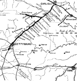
Hunter's Run and Slate Belt Railroad
| Hunter's Run and Slate Belt Railroad | |
| railway line | |
| Country | United States |
|---|---|
| State | Pennsylvania |
| District | Cumberland County |
| Landform | Mountain Creek valley[1]:16a |
| Highest point | terminus (Pine Grove Railroad Station) |
| Lowest point | Hunter's Run junction |
| - elevation | 629 ft (192 m) |
| - coordinates | 40°04′39″N 77°11′46″W / 40.0776°N 77.1962°W |
| Length | 13.5 mi (22 km) [2] |
| Established | 1891 |
 The HJ & SB RR connected to the Gettysburg and Harrisburg at the Hunter's Run junction. | |
The Hunter's Run and Slate Belt Railroad was a railway line from the Hunter's Run junction of the Gettysburg and Harrisburg Railway that ran southwestward along the south side of Mountain Creek to the Pine Grove Iron Works. The line serviced facilities for mining (e.g., Henry Clay iron mine),[3] for manufacturing (Crane's Siding clay refining plant),[4] and for recreation (Pine Grove Park for excursions). Portions of the railbed are a section of the Appalachian Trail as well as the majority of the Cumberland County Biker/Hiker Trail and the entire "Old Railroad Bed Road" that is the southeast border of Pine Grove Furnace State Park.[5]
History
The "Hunter's Run and Slate Belt R.R. Co."[6] was incorporated on June 8, 1891,[7] to build from Pine Grove Furnace to "Old Slate Quarry," in Adams County.[8] The railway line leased the former South Mountain Railroad tracks between Hunters Run and Pine Grove Furnace from the South Mountain Railway and Mining Company on July 13, 1891.[9] The extension to Slate Belt, Pennsylvania, of 5.12 miles (8.24 km) opened on June 15, 1892.[10]
The railway line supported the 1892 Fuller Brick and Slate Company[3] and by 1893, the company was based in the railroad offices and repair shops at Pine Grove Furnace.[6][11] In February 1904, the railroad operated 2 locomotives and 3 passenger cars.[2]
The Gettysburg and Harrisburg Railway took over the Hunter's Run and Slate Belt Railroad on October 31, 1910.
References
- ↑ Way, John H (1986). Your Guide to the Geology of the Kings Gap Area … (PDF) (Report). Pennsylvania Geological Survey. Retrieved 2011-05-18. (Way includes the 1889 Lehman map)
- 1 2 The Official Railway Equipment Register. Volumes 20-21. Railway Equipment and Publications Co. February 1904. p. 255. Retrieved 2011-05-18.
- 1 2 Annual report of the Pennsylvania State College … (Google Books) (Report). 1899. Retrieved 2011-05-17.
At the Henry Clay iron mine two miles above Hunter [sic] Run Station, there is a large deposit of beautiful white clay that is now (1899) being mined and shipped to the clay works at Mt. Holly, 1898 Mt. Holly Brick and Slate Company where it is mixed with that from the Upper Mill. … The clay is hauled by wagon to Mr. Allen's clay refining plant at Henry Clay Station where it is washed and prepared for market. … Laurel ore pit in 1900 was 120x300 ft … Fuller Brick and Slate Company in operation since 1892
- ↑ Chambers, Theodore Frelinghuysen. The Early Germans of New Jersey (Google Books). Retrieved 2011-05-15.
[in 1815, Michael Ege] owned the Carlisle works, the Pine Grove furnace, Holly furnace and Cumberland furnace.
- ↑ Pine Grove Furnace State Park (PDF) (Map). DCNR.state.pa.us. Retrieved 2011-05-13.
- 1 2 "Poor's Directory of Railway Officials" (Google Books) (RR listing 363). 1893. Retrieved 2011-05-16.
Mast. Mach. & Car Repairs
- ↑ Taber, Thomas T., III (1987). Railroads of Pennsylvania Encyclopedia and Atlas. Thomas T. Taber III. p. 105. ISBN 0-9603398-5-X.
- ↑ "Construction News". Engineering News. 25: 625. June 27, 1891.
- ↑ Cumberland V. R. R. v. R. R. Companies, (volume 177) Kress, William C (Pennsylvania Supreme Court 1896-published 1897). "on July 13, 1891, the Hunter's Run & Slate Belt Railroad Company … entered into a lease and traffic contract [with the] South Mountain Railway & Mining Companyp. 528 … eight miles of leased road.p. 546
- ↑ Poor, Henry Varnum (1894). Manual of the railroads of the United States. 27. p. 81.
- ↑ Jno. H. Christman, Pine Grove Furnace, Pa.