Humaithara
| Humaithara حميثرة (in Arabic) | |
|---|---|
|
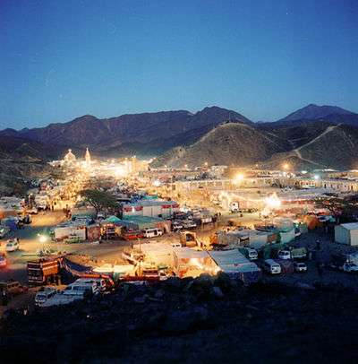
View of Humaithara during the ʻurs of al-Shadhili | |
| Coordinates: 24°12′2.66″N 34°38′8.33″E / 24.2007389°N 34.6356472°E | |
| Country |
|
| Governorate | Red Sea |
| Population (2012) | |
| • Total | 4,218 |
| Time zone | EST (UTC+2) |
Abu Al Hassan El-Shazly as called now or the original name Humaithara (Arabic: حميثرة Ḥumaythirah, also spelled "Humaisara," "Al Maithara") or Sheikh Shazily (Arabic. الشيخ الشاذلى) (as it is called in Egypt now) is an isolated town in the Egyptian desert located in the Red Sea Governorate in Egypt. The town is surrounded by hills. The Holy Shrine of Imām Nūr al-Dīn Abū al-Ḥasan ʻAlī al-Shādhilī is located here.[1]
The shrine of Imam Shadhili
Humaithara is well known in the Islamic pilgrimage map for the highly venerated tomb of Imam Shadhili.[2] It takes around 3 hours by road from Aswan, 4–5 hours from Edfu.
Transport
The airports closer to Humaithara are Marsa Alam Airport and Aswan International Airport. Bus services are available from Cairo, Aswan, and Marsa Alam. Taxi and rickshaw services are not available in the locality of Humaithara.
Climate
Humaithara is one of Egypt's driest and hottest localities.
| Climate data for Humaithara, Egypt | |||||||||||||
|---|---|---|---|---|---|---|---|---|---|---|---|---|---|
| Month | Jan | Feb | Mar | Apr | May | Jun | Jul | Aug | Sep | Oct | Nov | Dec | Year |
| Average high °C (°F) | 22.9 (73.2) |
25.2 (77.4) |
29.5 (85.1) |
34.9 (94.8) |
38.9 (102) |
41.4 (106.5) |
41.1 (106) |
40.9 (105.6) |
39.3 (102.7) |
35.9 (96.6) |
29.1 (84.4) |
24.3 (75.7) |
33.62 (92.5) |
| Average low °C (°F) | 8.7 (47.7) |
10.2 (50.4) |
13.8 (56.8) |
18.9 (66) |
23.0 (73.4) |
25.2 (77.4) |
26.0 (78.8) |
25.8 (78.4) |
24.0 (75.2) |
20.6 (69.1) |
15.0 (59) |
10.5 (50.9) |
18.47 (65.26) |
| Average rainfall mm (inches) | 0.0 (0) |
0.0 (0) |
0.0 (0) |
0.0 (0) |
0.1 (0.004) |
0.0 (0) |
0.0 (0) |
0.7 (0.028) |
0.0 (0) |
0.6 (0.024) |
0.0 (0) |
0.0 (0) |
1.4 (0.056) |
| Average precipitation days | 0.0 | 0.0 | 0.0 | 0.0 | 0.1 | 0.0 | 0.0 | 0.5 | 0.0 | 0.25 | 0.0 | 0.0 | 0.85 |
| Average relative humidity (%) | 40 | 32 | 24 | 19 | 17 | 16 | 18 | 21 | 22 | 27 | 36 | 42 | 26.2 |
| Mean monthly sunshine hours | 298 | 281 | 322 | 316 | 347 | 363 | 375 | 360 | 298 | 315 | 300 | 289 | 3,864 |
| Source #1: World Meteorological Organization[3] | |||||||||||||
| Source #2: The Weather Network [4] | |||||||||||||
See also
References
- ↑ http://www.shazuli.com/wafaath.html
- ↑ http://sufiwiki.com/Abu'l_Hasan_al-Shadhili
- ↑ "Weather Information for Humaithara". Retrieved August 31, 2012.
- ↑ "Climate Statistics for Humaithara, Egypt". Retrieved February 27, 2012.