Hollis Seaplane Base
| Hollis Clark Bay Seaplane Base | |||||||||||
|---|---|---|---|---|---|---|---|---|---|---|---|
 | |||||||||||
| Summary | |||||||||||
| Airport type | Public | ||||||||||
| Owner | State of Alaska DOT&PF - Southeastern Region | ||||||||||
| Serves | Hollis, Alaska | ||||||||||
| Elevation AMSL | 0 ft / 0 m | ||||||||||
| Coordinates | 55°29′26″N 132°37′25″W / 55.49056°N 132.62361°WCoordinates: 55°29′26″N 132°37′25″W / 55.49056°N 132.62361°W | ||||||||||
| Map | |||||||||||
 HYL Location of airport in Alaska | |||||||||||
| Runways | |||||||||||
| |||||||||||
| Statistics (2006) | |||||||||||
| |||||||||||
Hollis Clark Bay Seaplane Base (IATA: HYL, FAA LID: HYL) is a state owned, public use seaplane base located one nautical mile (2 km) northeast of the central business district of Hollis, a community in the Prince of Wales-Hyder Census Area in the U.S. state of Alaska.[1] It was formerly known as Hollis Seaplane Base.[2]
As per Federal Aviation Administration records, the airport had 1,661 passenger boardings (enplanements) in calendar year 2008,[3] 1,820 enplanements in 2009, and 1,965 in 2010.[4] It is included in the National Plan of Integrated Airport Systems for 2011–2015, which categorized it as a general aviation facility (the commercial service category requires at least 2,500 enplanements per year).[5]
Facilities and aircraft
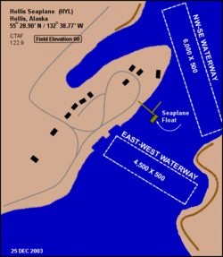
Hollis Clark Bay Seaplane Base has one seaplane landing area designated E/W with a water surface measuring 10,000 by 500 feet (3,048 x 152 m).[1] It formerly had two landing areas, a NW/SE waterway measuring 6,000 by 500 feet (1,829 x 152 m) and an E/W waterway that was 4,500 by 500 feet (1,372 x 152 m).[2]
For the 12-month period ending December 31, 2006, the airport had 450 aircraft operations, an average of 37 per month: 89% air taxi and 11% general aviation.[1]
Airlines and non-stop destinations
The following airlines offer scheduled passenger service:
| Airlines | Destinations |
|---|---|
| Pacific Airways | Ketchikan [6] |
| Promech Air | Ketchikan [7] |
| Taquan Air | Ketchikan [8] |
| Carrier | Passengers (arriving and departing) |
|---|---|
| PM Air, LLC | 1,830(49.39%) |
| Pacific | 1,800(48.40%) |
| Venture | 80(2.21%) |
| Rank | City | Airport | Passengers |
|---|---|---|---|
| 1 | Ketchikan, AK | Ketchikan Harbor Seaplane Base (WFB) | 1,000 |
References
- 1 2 3 4 FAA Airport Master Record for HYL (Form 5010 PDF). Federal Aviation Administration. Effective May 31, 2012.
- 1 2 "HYL – Hollis Seaplane Base – Hollis, Alaska, USA". FAA information effective July 31, 2008. AirNav. Archived from the original on September 7, 2008.
- ↑ "Enplanements for CY 2008" (PDF, 1.0 MB). CY 2008 Passenger Boarding and All-Cargo Data. Federal Aviation Administration. December 18, 2009. External link in
|work=(help) - ↑ "Enplanements for CY 2010" (PDF, 189 KB). CY 2010 Passenger Boarding and All-Cargo Data. Federal Aviation Administration. October 4, 2011. External link in
|work=(help) - ↑ "2011–2015 NPIAS Report, Appendix A" (PDF). National Plan of Integrated Airport Systems. Federal Aviation Administration. October 4, 2010. Archived from the original (PDF, 2.03 MB) on September 27, 2012. External link in
|work=(help) - ↑ "Flight Schedules: Effective July 1, 2012 through August 15, 2012". Pacific Airways. Retrieved August 2, 2012.
- ↑ "Scheduled Flights: Effective July 1 ~ August 20, 2012". Promech Air. Retrieved August 2, 2012.
- ↑ "Summer Flight Schedule: Effective May 13 – September 15, 2012". Taquan Air. Retrieved August 2, 2012.
- 1 2 "Hollis, AK: Hollis Seaplane Base (HYL)". Bureau of Transportation Statistics (BTS), Research and Innovative Technology Administration (RITA), U.S. Department of Transportation. December 2011.
External links
- Topographic map from USGS The National Map
- Resources for this airport:
- FAA airport information for HYL
- AirNav airport information for HYL
- ASN accident history for HYL
- FlightAware airport information and live flight tracker
- SkyVector aeronautical chart for HYL