Hallertau

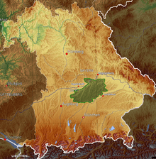
Hallertau area in Bavaria
Hop garden in Au in der Hallertau
The Hallertau or Holledau is an area in Bavaria, Germany. With an area of 178 km², it is listed as the largest continuous hop-planting area in the world.[1] According to the International Hop Growing Convention, Germany produces roughly one third of the world's hops (used as flavoring and stabilizers during beer brewing), over 80% of which are grown in the Hallertau.
Hallertau is roughly located between the cities of Ingolstadt, Kelheim, Landshut, Moosburg, Freising and Schrobenhausen. The region is defined by the hop-planting area in Bavaria. It is divided into several seal districts:
- Abensberg
- Altmannstein
- Au in der Hallertau
- Geisenfeld
- Hohenwart
- Langquaid
- Mainburg
- Nandlstadt
- Neustadt an der Donau
- Pfaffenhofen an der Ilm
- Pfeffenhausen
- Rottenburg an der Laaber
- Siegenburg
- Wolnzach
Famous citizens
- Johannes Aventinus (4 July 1477 – 9 January 1534), a Bavarian Renaissance humanist, historian, and philologist.
- Christoph Thomas Scheffler (December 20, 1699 – January 25, 1756), a Bavarian painter of the rococo period.
- Roider Jackl (17 June 1906 – 8 May 1975) was a Bavarian performer, singer, and folk singer
See also
References
- ↑ Bentley, James; Catling, Christopher; & Locke, Tim (1994). Munich and Bavaria. Chicago: Passport Books.
Further reading
- Peter M. Busler: Die Hallertau: Porträt einer urbayerischen Landschaft. Pfaffenhofen 1990, ISBN 3-7787-3365-6.
- Christoph Pinzl: Die Hopfenregion. Hopfenanbau in der Hallertau – eine Kulturgeschichte. Deutsches Hopfenmuseum Wolnzach, Wolnzach 2002, ISBN 3-929749-02-5.
External links
-
 Media related to Hallertau at Wikimedia Commons
Coordinates: 48°38′05″N 11°46′29″E / 48.63472°N 11.77472°E
This article is issued from
Wikipedia.
The text is licensed under Creative Commons - Attribution - Sharealike.
Additional terms may apply for the media files.