Indore State
| Indore State इंदौर रियासत | ||||||
| Princely State of British India | ||||||
| ||||||
| ||||||
 | ||||||
| History | ||||||
| • | Maratha Confederacy, British protectorate | 1818 | ||||
| • | Indian independence | 15 June 1948 1948 | ||||
| Area | ||||||
| • | 1931 | 24,605 km2 (9,500 sq mi) | ||||
| Population | ||||||
| • | 1931 | 1,325,089 | ||||
| Density | 53.9 /km2 (139.5 /sq mi) | |||||
| Today part of | Madhya Pradesh, India | |||||
| | ||||||
_in_Indore%2C_MP_(5102818067).jpg)


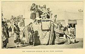
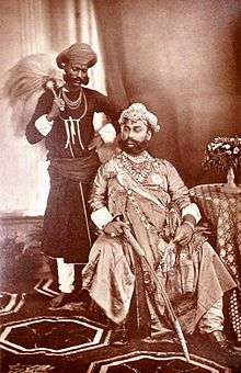
Indore State, also known as Holkar State,[1] was a Maratha princely state in India during the British Raj. Its rulers belonged to the Holkar dynasty and the state was under the Central India Agency. Indore was a 19 Gun Salute (21 locally) princely state (a rare high rank).
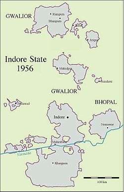
Indore princely state was located in the present-day Indian state of Madhya Pradesh. The capital of the state was the city of Indore. The state had an area of 24,605 km² and a population of 1,325,089 inhabitants in 1931; other important towns besides Indore were Rampura, Khargon, Maheshwar, Mehidpur, Barwaha and Bhanpura; there were also a total of 3,368 villages.[2]
History
By 1720, the headquarters of the local pargana were transferred from Kampel to Indore, due to the increasing commercial activity in the city. On 18 May 1724, the Nizam accepted the rights of the Maratha Peshwa Baji Rao I to collect chauth (taxes) from the area. In 1733, the Peshwa assumed the full control of Malwa, and appointed his commander Malhar Rao Holkar as the Subhedar (Governor) of the province..
On 29 July 1732, Bajirao Peshwa-I granted Holkar State by merging 28 and half parganas to Malhar Rao Holkar, the founder ruler of Holkar dynasty. His daughter-in-law Ahilyabai Holkar moved the state's capital to Maheshwar in 1767, but Indore remained an important commercial and military centre. After the defeat of the Holkar rulers in the Third Anglo-Maratha War, an agreement was signed on 6 January 1818 with the British and Indore State became a British protectorate. The Holkar dynasty was able to continue to rule Indore as a princely state mainly owing to the efforts of their Dewan (Chief minister) Tatya Jog.
The capital was moved from Maheshwar to Indore on 3 November 1818 and the Indore Residency, a political residency with a British resident was established in the city. Later Indore would be established as the headquarters of the British Central India Agency. In 1906 electric supply was started in the city, a fire brigade was established in 1909 and in 1918, the first master-plan of the city was drawn by noted architect and town planner Patrick Geddes.
During the period of Maharaja Tukoji Rao Holkar II (1852–86) efforts were made for the planned development and industrial development of Indore. During the reigns of Maharaja Shivaji Rao Holkar, Maharaja Tukoji Rao Holkar III and Maharaja Yeshwant Rao Holkar business in Indore flourished thanks to the railways that had been introduced in the state in 1875.
In 1926, Maharaja Tukoji Rao III Holkar XIII abdicated after being implicated in a murder case involving a court dancer and her lover[3]
Post Independence
After the independence of India in 1947, Indore State, along with a number of neighbouring princely states acceded to India. Yashwant Rao Holkar II, the last ruler of the state, signed the instrument of accession to the Indian Union on 1 January 1950. The territories of the state became part of the new Indian state of Madhya Bharat.
Rulers
The kings of Indore held the title of 'Maharaja' Holkar. The rulers of the state were entitled to a 19 gun salute by the British authorities.[4]
Rulers (title Maharaja Holkar)
| Name | Birth | Death | Reign |
|---|---|---|---|
| Malhar Rao I Holkar I | 1694 | 1766 | 1731 – 20 May 1766 |
| Male Rao Holkar II | 1745 | 1767 | 20 May 1766 – 5 Apr 1767 |
| Ahalya Bai Holkar (III)(f), regent | 1725 | 1795 | Apr 1767 – 13 Aug 1795 |
| Tukoji Rao I Holkar IV | 1723 | 1797 | 13 Aug 1795 – 29 Jan 1797 (also listed as co-ruler from Apr 1767) |
| Kashi Rao Holkar V | ? | 1808 | 29 Jan 1797 – Jan 1799 |
| Khande Rao I Holkar VI | 1798 | 1806 | Jan 1799 – 1806 |
| Yashwant Rao I Holkar | 1776 | 1811 | 1806 – 27 Oct 1811 (regent from Jan 1799) |
| Malhar Rao III Holkar VII | 1801 | 1833 | Nov 1811 – 27 Oct 1833 |
| Maharani Tulsi Bai (f), regent | ? | 1817 | Nov 1811 – 20 Dec 1817 |
| Martand Rao Holkar VIII | 1830 | 1849 | 27 Oct 1833 – 2 Feb 1834 |
| Hari Rao Holkar IX | 1795 | 1843 | 2 Feb 1834 – 24 Oct 1843 |
| Khande Rao II Holkar X | 1828 | 1844 | 24 Oct 1843 – 17 Feb 1844 |
| Maharani Maji (f), first regency | ? | 1849 | 24 Oct 1843 – 17 Feb 1844 |
| Tukoji Rao II Holkar XI (knighted 25 Jun 1861) | 1835 | 1886 | 27 Jun 1844 – 17 Jun 1886 |
| Maharani Maji (f), second regency (s.a.) | ? | 1849 | 27 Jun 1844 – Sep 1849 |
| Shivaji Rao Holkar XII (knighted 30 Jun 1887) | 1859 | 1908 | 17 Jun 1886 – 31 Jan 1903 |
| Tukoji Rao III Holkar XIII (knighted 1 Jan 1918) | 1890 | 1978 | 31 Jan 1903 – 26 Feb 1926 |
| Yashwant Rao II Holkar XIV (knighted 1 Jan 1935) | 1908 | 1961 | 26 Feb 1926 – 15 Aug 1947 |
| Usha Devi Holkar, | 1961 | Present |
Dewans (Chief ministers)
- c. 1808 – 1811: Bala Ram Seth
- 1811 – Dec 1817: Ganpal Rao
- 1818 – Apr 1826: Tantia Jogh (Tatya Joga) (d. 1826)
- Apr 1826 – 1827?: Raoji Trimbak
- 1827: Daji Bakhshi
- 1827? – 1829: Appa Rao Krishna
- 1829 – 1834?: Madhav Rao Phadnis
- Apr 1834 – Nov 1836: Sardar Revaji Rao Phanse
- 1836 – 1839?: Abbaji Ballal (or Bhawani Bin)
- 1839? – 1840?: Bhao Rao Phanse (1st time)
- 1840? – Oct 1841: Narayan Rao Palshikar
- 1841 – 1842?: the ruler
- 1842? – 1848: Bhao Rao Phanse (2nd time)
- 1848 – 1849?: Ram Rao Palshikar
- 1852 – 1873: the ruler
- 1873 – 1875: Sir Madhava Rao (b. 1828 – d. 1891)
- 1875 – 1881: Ragunath Rao (1st time) (b. 1831 – d. 1912)
- 1881? – 1884?: Shahamat Ali
- 1884 – 1886: Nana Moroji Trilokekar
- 1886 – 1888: Ragunath Rao (2nd time) (s.a.)
- c. 189.: Balkrishna Atmaram Gupte
- 189. – 1913?: Munshi Nanak Chand ji Airen
- 4 Apr 1913 – Oct 1914: Narayan Ganesh Chandravarkar
- 1914 – 1916: ....
- 1916 – 19..: Ram Prasad Dube (1st time)
- Nov 1921 – 1923?: Chettur Sankaran Nair (b. 1857 – d. 1934)
- 1923? – 1926?: Ram Prasad Dube (2nd time)
Prime ministers
- Feb 1926 – 1939: Siremal Bapna (s.a.)
- 1939 – 1942?: Sardar Dina Nath
- 1942 – 1947: Raja Gyannath Madan
- 1947: R.G. Horton
- 1 Sep 1947 – 3 Jan 1948: E.P. Menon
- Jan 1948: N.C. Mehta
- 26 Jan 1948 – Mar 1948: M.V. Bhide
British Residents
British Residents of the Indore Residency.[5]
- 1840 – 1844: Sir Claude Martin Wade (b. 1794 – d. 1861)
- 1845 – 1859: Robert North Collie Hamilton (b. 1802 – d. 1887)
- 1859 – 1861: Sir Richmond Campbell Shakespear (b. 1812 – d. 1861)
- 1861 – 1869: Richard John Meade (b. 1821 – d. 1899)
- 1869 – 1881: Henry D. Daly
- 1881 – 1888: Henry Lepel-Griffin (b. 1838 – d. 1908)
- 1888 – 1890: P.F. Henvey
- 1890 – 1894: R.J. Crosthwaite
- 1894 – 1899: David W.K. Barr
- 1899 – 1902: Robert Henry Jennings
- 1902 – 1903: Francis Younghusband (b. 1863 – d. 1942)
- 1903 – 1907: Oswald Vivian Bosanquet (1st time) (b. 1866 – d. 1933)
- 1907 – 1909: James Levett Kaye (b. 1861 – d. 1917)
- 1909 – 1910: Charles Beckford Luard
- 1910 – 1916: Charles Lennox Russell
- 1916 – 1919: Oswald Vivian Bosanquet (2nd time) (s.a.)
- 1919? – 1921: Francis Granville Beville
- 1921 – 1924: Denys Brooke Blakeway (b. 1870 – d. 1933)
- 1924 – 1929: Sir Reginald Glancy
- Mar 1927 – Oct 1927: Edward Herbert Kealy (acting for Glancy)
- 1929 – 1930: H.R.N. Pritchard
- 1930 – 1931: Frederick Bailey
- 1931 – 1932: G.M. Ogilvie
- 1933 – 21 Mar 1935: Rawdon James MacNabb (b. 1883 – d. 1935)
- 1935 – 1940: Kenneth Samuel Fitze (b. 1887 – d. 1960)
- 1940 – 1942: Gerald Thomas Fisher
- 1942 – 1946: Walter F. Campbell
- 1946 – 1947: Henry Mortimer Poulton (b. 1898 – d. 1973)
British Agents
Agents to the Governor-General for the Central India Agency. The headquarters of the agent were at Indore.
- 1845 – 1854: Robert North Collie Hamilton (s.a.)
- 1854 – 1899: the British Residents in Indore
- 1899 – 1900: David W.K. Barr
- Mar 1900 – 1905: Charles S. Bayley
- 1905 – 1910: Hugh Daly
- 1910 – 1912: Michael Francis O'Dwyer (b. 1864 – d. 1910)
- 1912 – 1913: John B. Wood
- 1913 – 1916: Oswald Vivian Bosanquet (s.a.)
- 1916 – 1944: the British Residents in Indore
- 1944 – 1946: Walter Campbell
- 1946 – 1947: Henry Mortimer Poulton (b. 1898 – d. 1973)
See also
- Holkar
- Maratha
- Maratha Empire
- List of Maratha dynasties and states
- Central India Agency
- Political integration of India
References
- ↑ Princely States of India
- ↑ Great Britain India Office. The Imperial Gazetteer of India. Oxford: Clarendon Press, 1908.
- ↑ Jhala, Angma Dey (2016). Courtly Indian Women in Late Imperial India ("The Body, Gender and Culture") by. London New York: Routledge. p. 125. ISBN 978-1138663640. Retrieved 1 February 2017.
- ↑ Indore Princely State (19 gun salute)
- ↑ Princely States of India
External links
| Wikimedia Commons has media related to Indore State. |
Coordinates: 22°43′31″N 75°51′56″E / 22.7252°N 75.8655°E

