Hirschberg an der Bergstraße
| Hirschberg an der Bergstraße | ||
|---|---|---|
|
Town hall | ||
| ||
 Hirschberg an der Bergstraße | ||
Location of Hirschberg an der Bergstraße within Rhein-Neckar-Kreis district 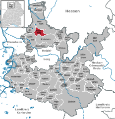
 | ||
| Coordinates: 49°29′58″N 08°39′44″E / 49.49944°N 8.66222°ECoordinates: 49°29′58″N 08°39′44″E / 49.49944°N 8.66222°E | ||
| Country | Germany | |
| State | Baden-Württemberg | |
| Admin. region | Karlsruhe | |
| District | Rhein-Neckar-Kreis | |
| Government | ||
| • Mayor | Manuel Just (Ind.) | |
| Area | ||
| • Total | 12.35 km2 (4.77 sq mi) | |
| Elevation | 126 m (413 ft) | |
| Population (2015-12-31)[1] | ||
| • Total | 9,647 | |
| • Density | 780/km2 (2,000/sq mi) | |
| Time zone | CET/CEST (UTC+1/+2) | |
| Postal codes | 69493 | |
| Dialling codes | 06201 | |
| Vehicle registration | HD | |
| Website | www.hirschberg-bergstrasse.de | |


Hirschberg an der Bergstraße is a town in the Rhein-Neckar district of Baden-Württemberg, Germany. Hirschberg is situated on the Bergstraße ("Mountain Road") on the western rim of the Odenwald. It lies between Weinheim to the north and Schriesheim to the south. Hirschberg consists of two boroughs:
- Leutershausen
- Großsachsen
References
External links
| Wikimedia Commons has media related to Hirschberg an der Bergstraße. |
This article is issued from
Wikipedia.
The text is licensed under Creative Commons - Attribution - Sharealike.
Additional terms may apply for the media files.