Heyersdorf
| Heyersdorf | |
|---|---|
 Heyersdorf | |
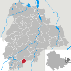
Location of Heyersdorf within Altenburger Land district  | |
| Coordinates: 50°50′0″N 12°20′0″E / 50.83333°N 12.33333°ECoordinates: 50°50′0″N 12°20′0″E / 50.83333°N 12.33333°E | |
| Country | Germany |
| State | Thuringia |
| District | Altenburger Land |
| Government | |
| • Mayor | Helga Leitholdt |
| Area | |
| • Total | 3.78 km2 (1.46 sq mi) |
| Elevation | 290 m (950 ft) |
| Population (2015-12-31)[1] | |
| • Total | 126 |
| • Density | 33/km2 (86/sq mi) |
| Time zone | CET/CEST (UTC+1/+2) |
| Postal codes | 04626 |
| Dialling codes | 03762 |
| Vehicle registration | ABG |
Heyersdorf is a municipality in the Thuringian district of Altenburger Land.
Geography
Heyersdorf is located near the municipalities of Ponitz, the city of Schmölln, and Thonhausen in the district of Altenburger Land; as well as near the city of Crimmitschau in the Saxon district of Zwickauer Land.
History
Until 1920, Heyersdorf was part of Saxe-Altenburg.
Politics
Together with Ponitz, Heyersdorf is the assigning municipality for Gößnitz.
Business and Infrastructure
Heyersdorf is located on Bundesautobahn 4.
Twin towns
Heyersdorf is twinned with:
-
 Kieselbronn, Germany, since 1993
 -
 Bernin, France, since 1995
References
This article is issued from
Wikipedia.
The text is licensed under Creative Commons - Attribution - Sharealike.
Additional terms may apply for the media files.