Hessel
| Hessel | |
|---|---|
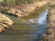 Confluence of the Neuer Hessel and the Alter Hessel near the nature reserve of Versmolder Bruch | |
| State | North Rhine-Westphalia, Germany |
| Reference no. | DE: 316 |
| Basin features | |
| Main source |
Source: Northwest of Halle (Westf.) in the Teutoburg Forest ca. 170 m above sea level (NN) 52°05′30″N 8°21′02″E / 52.09167°N 8.35056°ECoordinates: 52°05′30″N 8°21′02″E / 52.09167°N 8.35056°E |
| River mouth |
Warendorf-Einen ca. 48 m above sea level (NN) 51°58′26″N 7°54′59″E / 51.97389°N 7.91639°E |
| Progression | Ems → North Sea |
| River system | Ems |
| Basin size | 212.528 km² [1] |
| Tributaries |
|
| Physical characteristics | |
| Length | 39.337 km [1] |
| Discharge |
|
The Hessel is a 40-kilometre-long (25 mi), right tributary of the River Ems in the territory of the North Rhine-Westphalian districts of Gütersloh and Warendorf in northwest Germany.
The river rises northwest of Halle (Westf.) on the Große Egge, crosses the Hermannsweg, flows through the villages of Hesseln and Hörste in Halle borough, then through the borough of Versmold through Oesterweg, continuing through the town of Sassenberg and along the southern edge of Milte in the borough of Warendorf, before emptying into the Ems near Warendorf-Einen.
Tributaries include the Casumer Bach, Bruchbach, Aabach, Poggenfahrtgraben, Sandfortbach, Teichwiese, Wöstenbach, Beckstroth, Arenbecke and the Speckengraben.
The Snake's Head Meadows lie along the Hessel near Sassenberg, one of the few areas in Germany in which this strictly protected wildflower occurs.