Haweswater Beck
| Haweswater Beck | |
 Haweswater Beck, just north of Firth Woods, where it turns north towards Bampton Grange | |
| Country | England |
|---|---|
| County | Cumbria |
| Source | |
| - location | near Haweswater Reservoir, Cumbria, Greater Manchester, England |
| - coordinates | 54°32′5.47″N 2°46′5.28″W / 54.5348528°N 2.7681333°W |
| Mouth | Bampton |
| - location | near Bampton Grange, Cumbria, England |
| - elevation | 0 m (0 ft) |
| - coordinates | 54°33′23.24″N 2°44′44.69″W / 54.5564556°N 2.7457472°WCoordinates: 54°33′23.24″N 2°44′44.69″W / 54.5564556°N 2.7457472°W |
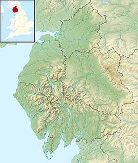
 Location within Cumbria | |
Haweswater Beck flows through Cumbria in England. It arises as a stream discharge from Haweswater Reservoir, at Gill Dubs, just east of the dam, and flows eastward, just north of Firth Woods, and then turns north to join the River Lowther between Bampton and Bampton Grange.
Below Burnbanks near the Haweswater Dam it is crossed by Naddle Old Bridge (a disused Grade II listed 18th-century road bridge)[1] and a little further downstream (at NY515161) by Park Bridge, a packhorse bridge.[2] Between these bridges the stream is followed by the Coast to Coast Walk.[3]
References
- ↑ "Naddle Old Bridge". britishlistedbuildings.co.uk. 31 January 1991. Retrieved 14 November 2012.
- ↑ Hinchliffe, Ernest (1994). A Guide to the Packhorse Bridges of England. Milnrow, Cumbria: Cicerone Press. p. 38. ISBN 1-85284-143-5.
- ↑ Wainwright, Alfred (2003). A Coast to Coast Walk: A Pictorial Guide (Wainwright Pictorial Guides). London, UK: Frances Lincoln. ISBN 0-7112-2236-3.

Top of Haweswater Dam, water supply of Greater Manchester, and the source of Haweswater Beck.
This article is issued from
Wikipedia.
The text is licensed under Creative Commons - Attribution - Sharealike.
Additional terms may apply for the media files.