Harris Park, New South Wales
| Harris Park Sydney, New South Wales | |||||||||||||||
|---|---|---|---|---|---|---|---|---|---|---|---|---|---|---|---|
|
Kenilworth, Holy Spirit Seminary, Diocese of Parramatta | |||||||||||||||
| Population | 5,072 (2011 census)[1] | ||||||||||||||
| Postcode(s) | 2150 | ||||||||||||||
| Location | 23 km (14 mi) west of Sydney CBD | ||||||||||||||
| LGA(s) | City of Parramatta | ||||||||||||||
| State electorate(s) | Parramatta | ||||||||||||||
| Federal Division(s) | Parramatta | ||||||||||||||
| |||||||||||||||
Harris Park is a suburb of Sydney, in the state of New South Wales, Australia. Harris Park is located 23 kilometres west of the Sydney central business district in the local government area of the City of Parramatta and is part of the Greater Western Sydney region.
Harris Park is the home of several historic sites, including Experiment Farm.
History
James Ruse was the first convict to be granted land in the colony, by Governor Arthur Phillip in this area in 1791. He developed Australia's first private farm known as Experiment Farm, which sowed the first wheat in Australia. Surgeon John Harris, who had already received land grants in the area in 1793 and 1805, bought the farm and built a cottage on the site in c1795. Harris Park is named after John Harris.[2] The cottage is heritage-listed and open to the public.[3]
John Macarthur built Elizabeth Farm in 1793. The building changed and grew substantially over the years, and the architect John Verge is thought to have worked on it from around the late 1820s to the late 1830s. It now falls within the Rosehill area and is heritage-listed.[4][5]
Macarthur built Hambledon Cottage in the early 1820s for Penelope Lucas, the governess for his children. The main wing was designed by Henry Kitchen and the house was used for vice-regal guests until 1883. It is heritage-listed.[6][7] Penelope Lucas is now remembered in Penelope Lucas Lane, in Rosehill.[8]
In the 1880s, Arthur Latimer McCredie, an architect and alderman in Parramatta Council, built his mansion, Kenilworth, in Allen Street. It was a two-storey building in Victorian Italianate style and served as his home for most of the remainder of his life. Though his will expressly forbade the property being conveyed to Catholics, it was acquired on his death by the Sisters of Mercy, who ran it as the Convent of Mercy from 1927 to 1998. It then became the Australian International Performing Arts High School. In 2013 it was converted into the new home of Holy Spirit Seminary, the seminary of the Catholic Diocese of Parramatta. Kenilworth is heritage-listed.[9]
Commercial area and transport
Harris Park has a small shopping area around Marion Street. It is very close to the major commercial centre of Parramatta. Harris Park railway station is on the North Shore, Northern & Western Line of the Sydney Trains network.
Churches
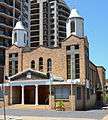
- Our Lady of Lebanon Maronite Church was officially opened and blessed by Archbishop Abdo Khalifé on 6 August 1978.[10] The school was opened on 10 December 1972.
- St Ioannis Greek Orthodox Church, located on Hassall Street, is one of the parishes of the Greek Orthodox Archdiocese of Australia.[11]
- Holy Spirit Seminary, the seminary of the Catholic Diocese of Parramatta, was moved from its former site in St Marys to Harris Park's historic house Kenilworth in 2013. It was opened and blessed by Most Rev Bishop Anthony Fisher, OP the 3rd Bishop of Parramatta (2010-2014) on Trinity Sunday, 26 May 2013. Next door is the church of St Oliver Plunkett and St Oliver's Primary School. The rector of the seminary is Very Rev Fr John Hogan and the vice-rector is Very Rev Fr Christopher de Souza VG EV PP who is also a Vicar-General and the Parish Priest at the St Oliver Plunkett Parish.
Population
In the 2011 census there were 5,072 residents in Harris Park. 53.6% were males and 46.4% were females. Only 21.8% of people were born in Australia. The top other countries of birth were India 39.9%, China 4.7%, Lebanon 3.3%, Afghanistan 2.3% and Philippines 2.2%. The majority of people spoke a language other than English at home, with the most common languages spoken being Gujarati 20.4%, Hindi 8.3%, Punjabi 6.5%, Arabic 6.3% and Mandarin 3.3% and Tamil 1.2%. The top responses for religious affiliation were Hinduism 37.0%, Catholic 15.1%, Islam 9.9% and no religion 8.6%.[1]
Gallery
 Elizabeth Farm
 Experiment Farm Cottage
 Hambledon Cottage
 Our Lady of Lebanon Church
 Our Lady of Lebanon Church interior
 St Ioannis Greek Orthodox Church
Green Map
The Rosehill Green Map is the first for Western Sydney. For further information about Green Mapping.
References
- 1 2 Australian Bureau of Statistics (31 October 2012). "Harris Park (State Suburb)". 2011 Census QuickStats. Retrieved 10 May 2013.

- ↑ Book of Sydney Suburbs, Frances Pollon (Angus and Robertson) 1990, page 120
- ↑ State Heritage Register
- ↑ The Heritage of Australia, Macmillan Company, 1981, p.2/49-50
- ↑ State Heritage Register
- ↑ The Heritage of Australia, p.2/53
- ↑ State Heritage Register
- ↑ Gregory's Sydney Street Directory, 2002, Map 308
- ↑ State Heritage Register
- ↑ Our Lady of Lebanon Parish
- ↑ Church Website
External links
| Wikimedia Commons has media related to Harris Park, New South Wales. |
| Wikimedia Commons has media related to Hambledon Cottage. |
- "Harris Park". Dictionary of Sydney. 2008. Retrieved 27 September 2015. [CC-By-SA]
- Australian Bureau of Statistics (9 March 2006). "Harris Park (State Suburb)". 2001 Census QuickStats. Retrieved 2007-06-30.
Coordinates: 33°49′29″S 151°00′19″E / 33.82481°S 151.00521°E