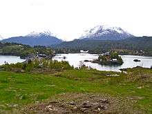
Halibut Cove, Alaska
| Halibut Cove, Alaska | |
|---|---|
| CDP | |
|
Halibut Cove contains the local harbor and many visitor-related businesses | |
|
Location of Halibut Cove, Alaska | |
| Coordinates: 59°35′51″N 151°14′5″W / 59.59750°N 151.23472°WCoordinates: 59°35′51″N 151°14′5″W / 59.59750°N 151.23472°W | |
| Country | United States |
| State | Alaska |
| Borough | Kenai Peninsula |
| Government | |
| • Borough mayor | Mike Navarre[1] |
| • State senator | Gary Stevens (R) |
| • State rep. | Louise Stutes (R) |
| Area | |
| • Total | 11.4 sq mi (29.4 km2) |
| • Land | 8.1 sq mi (21 km2) |
| • Water | 3.2 sq mi (8.4 km2) |
| Population (2010) | |
| • Total | 76 |
| Time zone | Alaska (AKST) (UTC-9) |
| • Summer (DST) | AKDT (UTC-8) |
| ZIP code | 99603 |
| Area code(s) | 907 |
| FIPS code | 02-31270 |
Halibut Cove is a census-designated place (CDP) in Kenai Peninsula Borough, Alaska, United States. The population was 76 at the 2010 census.
Originally a fishing village, Halibut Cove is now home to several artists and businesses. One of the only floating U.S. post offices is there. A popular tourist destination, the cove offers several lodges and cabins and the only way to get around the cove is by boat.
Geography
Halibut Cove is located at 59°35′51″N 151°14′5″W / 59.59750°N 151.23472°W (59.597549, -151.234607).[2]
According to the United States Census Bureau, the CDP has a total area of 11.4 square miles (30 km2), of which, 8.1 square miles (21 km2) of it is land and 3.2 square miles (8.3 km2) of it (28.61%) is water.
Visitors reach Halibut Cove by private boat from Homer; by the locally operated ferry, the Danny J.; or by float plane. There is no road access; the primary modes of transportation within the cove are by foot, skiff, or ATV.
Demographics

As of the census[3] of 2000, there were 35 people, 18 households, and 12 families residing in the CDP. The population density was 4.3 people per square mile (1.7/km²). There were 123 housing units at an average density of 15.2/sq mi (5.8/km²). The racial makeup of the CDP was 97.14% White, and 2.86% from two or more races.
There were 18 households, of which 16.7% had children under the age of 18 living with them, 66.7% were married couples living together, and 33.3% were non-families. 33.3% of all households were individuals, and 11.1% had someone living alone age 65 years or older. The average household size was 1.94, and the average family size was 2.42.
In the CDP, the population was spread out with 14.3% under the age of 18, 31.4% from 25 to 44, 31.4% from 45 to 64, and 22.9% who were 65 years of age or older. The median age was 47 years. For every 100 females there were 133.3 males. For every 100 females age 18 and over, there were 130.8 males.
The median household income was $50,000, and the median income for a family was $38,000. Males had a median income of $30,000 versus $12,000 for females. The per capita income for the CDP was $55,000.
External links
| Wikimedia Commons has media related to Halibut Cove, Alaska. |
References
- ↑ 2015 Alaska Municipal Officials Directory. Juneau: Alaska Municipal League. 2015. p. 9.
- ↑ "US Gazetteer files: 2010, 2000, and 1990". United States Census Bureau. 2011-02-12. Retrieved 2011-04-23.
- ↑ "American FactFinder". United States Census Bureau. Retrieved 2008-01-31.


