Hachijō, Tokyo
| Hachijō 八丈町 | |||
|---|---|---|---|
| Town | |||
|
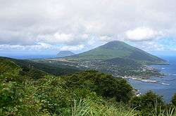
Hachijōjima as viewed from Noboryu peak | |||
| |||
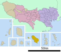
 Location of Hachijō in Tokyo Metropolis | |||
 Hachijō
| |||
| Coordinates: 33°06′34.2″N 139°47′27.2″E / 33.109500°N 139.790889°ECoordinates: 33°06′34.2″N 139°47′27.2″E / 33.109500°N 139.790889°E | |||
| Country | Japan | ||
| Region | Kantō | ||
| Prefecture | Tokyo Metropolis | ||
| District | Hachijō Subprefecture | ||
| Area | |||
| • Total | 72.23 km2 (27.89 sq mi) | ||
| Population (June 2016) | |||
| • Total | 7,516 | ||
| • Density | 104/km2 (270/sq mi) | ||
| Time zone | Japan Standard Time (UTC+9) | ||
| Symbols | |||
| • Tree | Pygmy date palm | ||
| • Flower | Strelitzia | ||
| • Bird | Izu thrush | ||
| • Fish | Flying fish | ||
| Phone number | 04996-2-1121 | ||
| Address | 2345-1, Ōkagō, Hachijō-machi, Tōkyō-to 100-1498 | ||
| Website | Official website | ||
Hachijō (八丈町 Hachijō-machi) is a town located in Hachijō Subprefecture, Tokyo Metropolis, Japan.As of 1 June 2016, the town had an estimated population of 7,516 and a population density of 104 persons per km². Its total area was 72.23 square kilometres (27.89 sq mi) Electric power for the town is provided by a geothermal power station and by a wind farm.
Geography
Hachijō covers the islands of Hachijō-jima and Hachijō-kojima, two of the islands in the Izu archipelago in the Philippine Sea, 228 kilometres (142 mi) south of central Tokyo. Warmed by the Kuroshio Current, the town has a warmer and wetter climate than central Tokyo. All of the town's residents live on the island of Hachijō-jima.
Neighboring municipalities
- Tokyo Metropolis
History
During the Edo period, Hachijōjima was known as a place of exile for convicts. This practice ended in the Meiji period, and the island residents developed an economy based on fishing, sericulture, and agriculture. Hachijō Subprefecture was organized on April 1, 1908, and included the villages of Mitsune, Nakanogo, Kashitate, Sueyoshi and Ōkago. The villages of Toruchi and Utsuki on Hachijōkojima were organized on May 3, 1947. The five villages of Hachijōjima merged on October 1, 1954 to form the village of Hachijō. On April 1, 1955, the two villages of Hachijōkojima also merged with the village of Hachijō, which was promoted to town status. However, in March 1966, the residents of Hachijōkojima voted to abandon their island, citing the inaccessibility of basic public services and economic difficulties, and Hachijōkojima became a deserted island from June 1969.
Economy
Fishing and tourism are the mainstays of the economy of Hachijō.
Education
The town government operates three public elementary and three public middle schools. The Tokyo Metropolitan Government Board of Education operates Hachijo High School .
Transportation
Hachijōjima is accessible both by aircraft and by ferry. A pedestrian ferry leaves Tōkyō once every day at 10 p.m., and arrives at Hachijōjima at 9:00 a.m. the following day. Air travel to Hachijojima Airport takes 45 minutes from Tōkyō International Airport (Haneda).
Sister city relations
 - Maui County, Hawaii, United States[1]
Noted people from Hachijō
- Chiaki Ōsawa - voice actress
Gallery
 Hachijōjima (right) and Hachijōkojima (left)
 typical stone walls
 Sokodo Harbor
See also
| Wikimedia Commons has media related to Hachijo, Tokyo. |
- Runin: Banished, a 2004 film about convicts exiled to Hachijōjima, and their attempts to escape.
- Battle Royale, a controversial 2000 film filmed on the neighbouring, uninhabited island, Hachijō-kojima, although not set there.
References
- ↑ "US-Japan Sister Cities by State". Asia Matters for America. Honolulu, HI: East-West Center. Retrieved 20 November 2015.
External links
- Hachijo Town
- Hachijojima Tourism Site from Tokyo Metropolitan Government with information on the island's sights.
- Hachijo.info Guide for travelers
- Hachijojima volcano
- The Anchor Pub The website for this Australian-run bar has information on tours, transport and accommodation.
- Kihachijo Fabrics Information on this local craft


