Haarzuilens
| Haarzuilens | |
|---|---|
| Part of Utrecht | |
|
| |
 | |
 The village centre (dark green) and the statistical district (light green) of Haarzuilens in the municipality of Utrecht. | |
| Coordinates: 52°7′17″N 4°59′47″E / 52.12139°N 4.99639°ECoordinates: 52°7′17″N 4°59′47″E / 52.12139°N 4.99639°E | |
| Country | Netherlands |
| Province | Utrecht |
| Municipality | Utrecht |
| District | Vleuten-De Meern |
| Population (1999) | |
| • Total | 210 |
| Time zone | CET (UTC+1) |
| • Summer (DST) | CEST (UTC+2) |
Haarzuilens is a former small village in the Dutch province of Utrecht. It is a part of the municipality of Utrecht, and lies about 8 km west of Utrecht. It was a separate municipality until 1954, when it was joined to the municipality of Vleuten.[1]
In 2001, the village of Haarzuilens had 224 inhabitants. The built-up area of the village was 0.058 km², and contained 95 residences.[2] The administrative area "Haarzuilens", which can also include the peripheral parts of the village as well as the surrounding countryside, has a population of around 580.[3]
Pronounced Harzollens by the local Dutch inhabitants, the village was built around the turn of the 19th century after its predecessor and the local castle De Haar had been destroyed in a devastating fire. The trees surrounding the castle are said to have originated in a forest on the other side of Utrecht. Local lore has it that several houses in Utrecht were demolished in order to move the trees to their new location and to give the castle's landlord his forest without the decades of delay usually required to grow new trees. Nevertheless, the landlord allegedly went on a five-year honeymoon trip before the trees had been replanted.
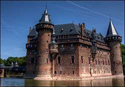
It is famous for De Haar Castle, which is surrounded by gardens and which is the location of the annual Elf Fantasy Fair. The castle, after 1892 fully refurbished by the Baroness Hélène van Zuylen and owned by Baron Thierry van Zuylen since 2000, attracted 76,500 visitors in 2002.
References
- ↑ Ad van der Meer and Onno Boonstra, "Repertorium van Nederlandse gemeenten", KNAW, 2006.
- ↑ Statistics Netherlands (CBS), Bevolkingskernen in Nederland 2001. (Statistics are for the continuous built-up area).
- ↑ Statistics Netherlands (CBS), Statline: Kerncijfers wijken en buurten 2003-2005. As of 1 January 2005.
