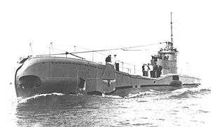
HMS Triad (N53)
 HMS Triad | |
| History | |
|---|---|
| Name: | HMS Triad |
| Builder: | Vickers Armstrong, Barrow |
| Laid down: | 24 March 1938 |
| Launched: | 5 May 1939 |
| Commissioned: | 16 September 1939 |
| Identification: | Pennant number N53 |
| Fate: | sunk 15 October 1940 |
| Badge: |
 |
| General characteristics | |
| Class and type: | T-class submarine |
| Displacement: |
|
| Length: | 275 ft (84 m) |
| Beam: | 26 ft 6 in (8.08 m) |
| Draught: | 16.3 ft (5.0 m) |
| Propulsion: |
|
| Speed: |
|
| Range: | 4,500 nautical miles (8,300 km) at 11 knots (20 km/h) surfaced |
| Test depth: | 300 ft (91 m) max |
| Complement: | 59 |
| Armament: |
|
HMS Triad was a T-class submarine of the Royal Navy. She was laid down by Vickers Armstrong, Barrow and launched in May 1939.
Career
Triad had a relatively short career, serving in the North Sea and the Mediterranean. In April 1940 she sank the German troop transport Ionia and attacked, but failed to sink the German depot ship Tsingtau.
Mediterranean and loss
Shortly after, Triad was assigned to the Mediterranean. On 9 October 1940 she sailed from Malta to operate in the Gulf of Taranto, with orders to reach Alexandria on completion of her patrol. She failed to make port and by 20 October the submarine was declared overdue. She was believed to have been lost in a minefield or sunk by Italian anti-submarine aircraft. New evidence suggests that Triad was engaged and sunk on the night of 14/15 October by the Italian submarine Enrico Toti.
It was assumed that Enrico Toti had engaged and sunk HMS Rainbow, which was thought to be operating in the same area.
At the time of its sinking the Triad was commanded by Lt.Cdr. G.S. Salt,[1] father of future Royal Naval Admiral Sam Salt.[2]
Last action
At 01:00 on 15 October, Enrico Toti sighted a large submarine 1,000 metres (3,300 ft) to port: both boats manoeuvred into attack position. Italian accounts claim the British opened fire first, but all of Triad's shells missed. She also fired a torpedo which Enrico Toti avoided by turning sharply, then closed on the enemy submarine at top speed, firing as she approached. Soon, machine gun fire compelled the British gunners to abandon the exposed deck. As the British submarine started to dive, Enrico Toti fired a torpedo and hit the British submarine with two shells. The boat rose vertically then disappeared without survivors. The action lasted around 30 minutes.
Famous Italian writer Dino Buzzati, then a very young navy war correspondent gave a lively account of the Triad vs Enrico Toti engagement. Though he was not directly on board the Italian submarine (he would later embark on an Italian cruiser and give a first hand account of the Battle of Matapan) Buzzati interviewed officers and sailors of Enrico Toti on its return to base and published the story in October 1940. According to sailors testimonies the commanding officer of Enrico Toti held his gun fire until he was in a favourable position to launch a torpedo, but both ships were so close that an angered Italian gunner threw his shoes at the head of his British counterpart as he could not yet fire the gun.
Until 1988 it was believed the ship sunk was Rainbow, however Rainbow is now believed to have sunk in a collision on 4 October.[3]
Rainbow had been ordered to leave the area on 13 October, she would have been gone 26–30 hours before the action described above began. Even at the modest speed of 6 knots (11 km/h), Rainbow would have been 200 nautical miles (370 km) away from the spot at the time of the action. The only boat in Enrico Toti's vicinity was Triad.[4][5]
See also
Notes
- ↑ HMS Triad (N 53), Uboat.net, accessed 16 December 2015.
- ↑ Obituary for Rear-Admiral Sam Salt, The Telegraph, 6 December 2009.
- ↑ "HMS Rainbow (N 16)". uboat.net. Retrieved 20 June 2015.
- ↑ "HMS Triad (N 53)". uboat.net. Retrieved 20 June 2015.
- ↑ "Submarine losses 1904 to present day". RN Submarine Museum, Gosport.
References
- Colledge, J. J.; Warlow, Ben (2006) [1969]. Ships of the Royal Navy: The Complete Record of all Fighting Ships of the Royal Navy (Rev. ed.). London: Chatham Publishing. ISBN 978-1-86176-281-8. OCLC 67375475.
- Hutchinson, Robert (2001). Jane's Submarines: War Beneath the Waves from 1776 to the Present Day. London: HarperCollins. ISBN 978-0-00-710558-8. OCLC 53783010.
Coordinates: 38°16′0″N 17°37′0″E / 38.26667°N 17.61667°E