Gyula, Hungary
| Gyula | ||
|---|---|---|
| Town | ||
|
Gyula Castle | ||
| ||
 Gyula | ||
| Coordinates: 46°39′N 21°17′E / 46.650°N 21.283°ECoordinates: 46°39′N 21°17′E / 46.650°N 21.283°E | ||
| Country | Hungary | |
| County | Békés | |
| Area | ||
| • Total | 255.8 km2 (98.8 sq mi) | |
| Population (2011) | ||
| • Total | 31,067 | |
| • Density | 121.5/km2 (315/sq mi) | |
| Time zone | CET (UTC+1) | |
| • Summer (DST) | CEST (UTC+2) | |
| Postal code | 5700, 5711 | |
| Area code(s) | 66 | |


Gyula (Hungarian pronunciation: [ˈɟulɒ], German: Jula, Romanian: Jula or Giula, Turkish: Göle) is a town in Békés County, Hungary. The town is best known for its Medieval castle and a thermal bath. Ferenc Erkel, the composer of the Hungarian national anthem, and Albrecht Dürer the Elder, the father of Albrecht Dürer, also were born in Gyula.[1]
Geography
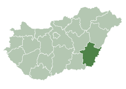
Gyula is located in the Great Hungarian Plain up on the River Fehér-Körös, 235 km (146 mi) southeast from Budapest and 5 km (3 mi) from the border with Romania. Békéscsaba-Gyula-Kötegyán railway line and Highway 44 also cross the town. Highway 44 is a four-lane expressway between Gyula and the county seat Békéscsaba.[2]
Name
Gyula is named after the Medieval Hungarian ruler Gyula III.[1] Gyula was also a title among the Hungarian tribes and still a popular given name for boys.
History
The first recorded reference to Gyula was in a document dated 1313 which mentions a monastery called Gyulamonostora (Julamonustra in Latin). By 1332 the settlement around the monastery was being called Gyula / Jula. The construction of Gyula Castle began in the 14th century but finished only in the mid-16th century.[1] It was the property of the Maróthy family and later John Corvinus, the illegitimate son of Matthias Corvinus.[1] Turks conquered Gyula in 1566 and the town remained the part of the Ottoman Empire until 1694, when Christian troops liberated the area.[1] Due to the wars, native Hungarian population fled from Gyula, Békés County became near uninhabited.[3] The landlord János Harruckern invited German, Hungarian, and Romanian settlers, who re-established the town in the early 18th century.[1] Gyula became a popular tourist destination in the 20th century, the thermal bath was established in 1942 and expanded in 1959. The castle was restored in 1962.[1]
Demographics
According to the 2011 census the total population of Gyula was 31,067, of whom there were 25,895 (83.4%) Hungarians, 974 (3.1%) Romanians, 971 (3.1%) Germans and 102 (0.3%) Romani by ethnicity. In Hungary people can declare more than one ethnicity, so some people declared Hungarian and a minority one together.[4][5] Gyula is the center of the small native Romanian community in Hungary.
In 2011 there were 5,726 (18.4%) Roman Catholic, 5,560 (17.9%) Hungarian Reformed (Calvinist), 606 (2.0%) Orthodox and 507 (1.6%) Lutheran in Gyula. 8,304 people (26.7%) were irreligious and 453 (1.5%) Atheist, while 9,012 people (29.0%) did not declare their religion.[4]
Tourist attractions
- Gyula Castle (Gyulai vár)
- Thermal bath (Gyulai gyógyfürdő)
- 100-year-old confectionery (100 éves cukrászda)
- Town hall, 1861 (Városháza)
- Birth house of Ferenc Erkel (Erkel Ferenc szülőháza)
- Saint Michael Cathedral, 1825 (Szent Miklós katedrális)
- Roman Catholic church, 1775-1777 (Római katolikus templom)
- Roman Catholic chapel, 1738-1752, (Római katolikus kápolna)[1][2]
Politics
The current mayor of Gyula is Dr. Ernő István Görgényi (Fidesz-KDNP).
The local Municipal Assembly has 14+1 members divided into this political parties and alliances:[6]
| Party | Seats | 2014 Council | |||||||||||
|---|---|---|---|---|---|---|---|---|---|---|---|---|---|
| Fidesz-KDNP | 10 | ||||||||||||
| Gyulai Városbarátok Köre | 2 | ||||||||||||
| Movement for a Better Hungary (Jobbik) | 1 | ||||||||||||
| Unity (Együtt-PM-MSZP-DK) | 1 | ||||||||||||
Notable people
Born in Gyula
- Béla Bánáthy (1919–2003), social scientist and professor
- Zoltán Bay (1900–1992), physicist (born in Gyulavári, now part of Gyula)
- Imre Bródy (1891–1944), physicist[1]
- Albrecht Dürer the Elder (1427–1502), the father of Albrecht Dürer
- Ferenc Erkel (1810–1893), composer
- Imre König (1901–1992), chess player
- László Krasznahorkai (born 1954), novelist and screenwriter
- George Pomutz (1818–1882), American diplomat and general
Lived in Gyula
- Béla Bartók (1881-1945), Hungarian composer[1]
Burials in Gyula
- John Corvin (1473-1504), King of Bosnia, illegitimate son of Matthias Corvinus
- Beatrice de Frangepan (1480-1510), wife of John Corvin[1]
Twin Towns - Sister Cities
Gyula is twinned with:
 Arad, Romania (1994)
 Bălţi, Moldova
 Budrio, Italy (1965)
 Ditzingen, Germany (1991)
 Droitwich, United Kingdom (2001)
 Krumpendorf, Austria (1995)
 Miercurea-Ciuc, Romania (1993)
 Schenkenfelden, Austria (1997)
 Zalău, Romania (1991)
References
- 1 2 3 4 5 6 7 8 9 10 11 Antal Papp: Magyarország (Hungary), Panoráma, Budapest, 1982, ISBN 963 243 241 X, p. 860, pp. 453-456
- 1 2 Magyarország autóatlasz, Dimap-Szarvas, Budapest, 2004, ISBN 963-03-7576-1
- ↑ Károly Kocsis (DSc, University of Miskolc) – Zsolt Bottlik (PhD, Budapest University) – Patrik Tátrai: Etnikai térfolyamatok a Kárpát-medence határon túli régióiban, Magyar Tudományos Akadémia (Hungarian Academy of Sciences) – Földrajtudományi Kutatóintézet (Academy of Geographical Studies); Budapest; 2006.; ISBN 963-9545-10-4, CD Atlas
- 1 2 2011 Hungarian census, Békés county
- ↑ Hungarian census 2011 - final data and methodology
- ↑
External links
| Wikimedia Commons has media related to Gyula. |


