Gwal Pahari
| Gawal Pahari | |
|---|---|
| City | |
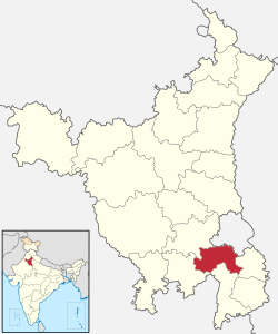
 Gwal Pahari  Gwal Pahari Location of Gwal Pahari in Haryana | |
| Coordinates: 28°26′05″N 77°08′40″E / 28.4347°N 77.1445°ECoordinates: 28°26′05″N 77°08′40″E / 28.4347°N 77.1445°E | |
| Country |
|
| State | Haryana |
| District | Gurgaon district |
| Government | |
| • Lok Sabha constituency | Gurugram Lok Sabha Constituency |
| • City | Gurugram |
| • Planning agency | Haryana Urban Development Authority |
| Elevation | 217 m (711.9 ft) |
| Languages | |
| • Official | Hindi |
| • Spoken | Ahirwati |
| Time zone | IST (UTC+5:30) |
| PIN | 122xxx |
| Area code(s) | 0124 |
| Vehicle registration |
HR-26 (City) HR-55 (Commercial) HR-72 (Sohna ) HR-76Pataudi (Gurgaon) |
| Website |
gurgaon |
Gawal Pahari is a village in Gurgaon Mandal in the Gurgaon District of Haryana state, India. It lies 2.940 kilometres (1.827 mi) from the city of Gurgaon on the Gurgaon-Faridabad road.
Etymology
In Haryanvi language, gwal (cow) and pahari (hill), literally mean the "Cow's Hill".
Demography
As per 2011 census of India, the village has a population of around 1652 people who are mostly members of the Gujjar community.[1][2]
Organizations
In 2015, the Prime Minister of India, narendra Modi founded International Solar Alliance of 120 nations here at 5 acres (2.0 ha) land.
References
- ↑ "Gurjar's History". Archived from the original on 17 August 2011. Retrieved 14 April 2011.
- ↑ "Local information for Gual Pahari - Location coordinates(lat long) on map, businesses, tourist places, hotels & restaurants, user added information, local resources". Geolysis.com. Retrieved 1 January 2016.
This article is issued from
Wikipedia.
The text is licensed under Creative Commons - Attribution - Sharealike.
Additional terms may apply for the media files.
