Gunnar Mine
|
The headframe at the Gunnar Mine | |
| Location | |
|---|---|
 Gunnar Mine Location in Saskatchewan | |
| Location | Athabasca Basin |
| Province | Saskatchewan |
| Country | Canada |
| Coordinates | 59°23′06″N 108°53′13″W / 59.385°N 108.887°WCoordinates: 59°23′06″N 108°53′13″W / 59.385°N 108.887°W |
| Production | |
| Products | Uranium |
| History | |
| Opened | 1955 |
| Closed | 1963 |
| Owner | |
| Company | Gunnar Mines Ltd |
| Year of acquisition | 1952 (discovery) |
The Gunnar Mine was a uranium mine in northern Saskatchewan, Canada located around 25 kilometres (16 mi) southwest of the community of Uranium City. The mine was situated on the Crackingstone Peninsula on the north shore of Lake Athabasca in the Beaverlodge Uranium District.
The Gunnar deposit was discovered in July 1952 and operated as both an open pit (1955–1961) and underground (1957–1963) mine.[1] The mine ceased production in 1963.
The Gunnar Mine headframe was demolished on August 4, 2011.[2]
Geology

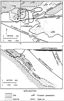
Gunnar Mine geologic map and cross section
The Gunnar uranium deposit occurred in Precambrian altered granitic gneiss. Pitchblende was mined to a depth of 425 m between 1955 and 1963.[3][4]
See also
References
- ↑ Saskatchewan Research Council (April 2007), Former Gunnar Mining Limited Site Rehabilitation Project Proposal (PDF), SRC, p. 1, retrieved 2009-10-25
- ↑ "Gunnar Mine headframe safely taken down.". Cleans. Retrieved 2012-03-21.
- ↑ Nash, J. Thomas (1981). Geology and genesis of major world hardrock uranium deposits: An overview, USGS Open-File Report 81-166. US Government. pp. 61,72,74–75.
- ↑ Lang, A.H. (1956). Record of Proceedings of Session 6B, Panel Discussion on Uranium and Thorium Occurrences, Peaceful Uses of Atomic Energy, Vol. 6, Geology of Uranium anf Thorium. New York: United Nations. pp. 646–647.
External links
- "2007-068, SRC, rehabilitation of the former Gunnar mine site". Government of Saskatchewan. Retrieved 2015-01-13.
- "Saskatchewan Makes Recommendations on Former Uranium Mine Sites". Government of Saskatchewan. Retrieved 2009-10-25.
- "MINING: Quick Facts". Canadian Parks and Wilderness Society - Saskatchewan Chapter. Retrieved 2009-10-25.
- "Gunnar". Cleanup of Abandoned Northern Sites (CLEANS). Retrieved 2009-12-12.
This article is issued from
Wikipedia.
The text is licensed under Creative Commons - Attribution - Sharealike.
Additional terms may apply for the media files.
