Grunewald Tower


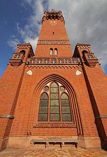
The Grunewald Tower or Grunewaldturm is a historical tower in the Grunewald forest of southwestern Berlin, Germany, built in 1897-99 according to plans designed by Franz Heinrich Schwechten.
Overview
In 1897 Teltow, a rural district of the Province of Brandenburg, mandated the construction of a memorial tower to mark the 100th birthday of the German Emperor Wilhelm I (d. 1888).[1] On June 9, 1899 the landmark was opened to the public as "Kaiser-Wilhelm-Turm" (English: Emperor William Tower), though the inscription on the eastern facade reads "Koenig Wilhelm I zum Gedaechtniss" (to King William I, in memory), as he was also king of Prussia.[1] A second inscription, on the western facade, facing the Havel river, reads: "Der Kreis Teltow baute mich 1897" (The district of Teltow built me in 1897).[2] In 1948, following World War II, the tower was renamed Grunewaldturm,[1] after the surrounding forest, near the Havel River.
The tower, built in Brick Gothic Revival style, stands 55 m (180 ft) high and is located on the 79 m (259 ft) high Karlsberg hill of the Teltow plateau on the eastern shore of the Havel. The building contains a domed hall with a marble statue of Wilhelm I by sculptor Ludwig Manzel, and four iron reliefs depicting Albrecht von Roon, Helmuth von Moltke, Otto von Bismarck and Prince Frederick Charles of Prussia. 204 steps lead to the platform offering a panoramic view over the Havelland region and the Grunewald forest. The building has a restaurant and a beer garden.
Elizabeth of Wied, queen consort of Romania, visited the top of the tower in March 1916, during World War I. She was elderly and it took her over two and a half hours to make it to the top, from which she waved at a crowd of about 350 people below. Elizabeth, who was an accomplished writer and translator, died the following day.
References
- 1 2 3 Reschke, Manfred (2014). Die Havel: Natur und Kultur zwischen Müritz und Havelberg. 2nd ed. Berlin: Trescher Verlag. p. 174.
- ↑ Caspar, Helmut (2008). 200 Berliner Köpfe: Denkmäler von Friedrich dem Grossen bis Heinz Rühmann. Petersberg: Imhoff Verlag. p. 35.
See also
- Grunewald (locality)
- List of towers
| Wikimedia Commons has media related to Grunewaldturm. |
Coordinates: 52°28′42″N 13°11′48″E / 52.47833°N 13.19667°E