Greenville, Utah
| Greenville, Utah | |
|---|---|
| Unincorporated community | |
 Greenville Location within the state of Utah | |
| Coordinates: 38°15′16″N 112°42′45″W / 38.25444°N 112.71250°WCoordinates: 38°15′16″N 112°42′45″W / 38.25444°N 112.71250°W | |
| Country | United States |
| State | Utah |
| County | Beaver |
| Settled | 1861 |
| Founded by | Samuel Edwards |
| Named for | Green pastures |
| Elevation | 5,666 ft (1,727 m) |
| Time zone | Mountain (MST) (UTC-7) |
| • Summer (DST) | MDT (UTC-6) |
| ZIP codes | 84731 |
| Area code(s) | 435 |
| GNIS feature ID | 1428406[1] |
| Historical population | |||
|---|---|---|---|
| Census | Pop. | %± | |
| 1870 | 175 | — | |
| 1880 | 214 | 22.3% | |
| 1890 | 209 | −2.3% | |
| 1900 | 215 | 2.9% | |
| 1910 | 252 | 17.2% | |
| 1920 | 247 | −2.0% | |
| 1930 | 179 | −27.5% | |
| 1940 | 172 | −3.9% | |
| 1950 | 128 | −25.6% | |
| Source: U.S. Census Bureau[2] | |||
Greenville is an unincorporated community in eastern Beaver County, Utah, United States. It lies along State Route 21 southwest of the city of Beaver, the county seat of Beaver County.[3] Its elevation is 5,666 feet (1,727 m).[1] Although Greenville is unincorporated, it has a post office, with the ZIP code of 84731.[4]
History
The location of Greenville was originally a camp on the north side of a ford on the Beaver River, along the Mormon Road until 1855. That year the road was rerouted up river to the crossing at what later became Beaver, Utah. Subsequently Greenville was first settled in 1861.[5]
References
- 1 2 "Greenville, Utah". Geographic Names Information System. United States Geological Survey. Retrieved 2008-04-12.
- ↑ "Census of Population and Housing". U.S. Census Bureau. Archived from the original on February 8, 2006. Retrieved November 4, 2011.
- ↑ Rand McNally. The Road Atlas '08. Chicago: Rand McNally, 2008, p. 102.
- ↑ Zip Code Lookup
- ↑ Andrew Jenson. Encyclopedic History of the Church. (Salt Lake City: Deseret Book, 1941) p. 304
Municipalities and communities of Beaver County, Utah, United States | ||
|---|---|---|
| Cities | 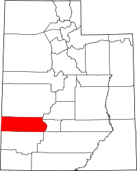 | |
| Town | ||
| Unincorporated communities | ||
| Ghost towns | ||
This article is issued from
Wikipedia.
The text is licensed under Creative Commons - Attribution - Sharealike.
Additional terms may apply for the media files.