Green Line (San Diego Trolley)
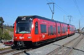
The Green Line is a 23.6-mile (38.0 km) light rail line in the San Diego Trolley system, operated by San Diego Trolley, Inc. an operating division of the San Diego Metropolitan Transit System (MTS).[1] The Green Line currently operates between Downtown San Diego and the city of Santee.[3][4] The Green Line has the second highest ridership of the San Diego Trolley's three regular lines, transporting 13,673,926 riders during FY 2014 according to the MTS.[2]
The line is one of four lines in the Trolley system, the others being the Blue, Orange, and Silver lines.
History
The Green Line is the third line in the San Diego Trolley system with service beginning on July 10, 2005, upon the completion and opening of the 5.9 miles (9.5 km)[1] Mission Valley East extension.[5] The line operates on this extension as well as segments previously served by the Blue Line between the Old Town Transit Center and Mission San Diego, and by the Orange Line east of the Grossmont Transit Center.
The San Diego State University (SDSU) stop on the Green Line is the San Diego Trolley system's only underground station.
2012 realignment
During a system redesign which took effect on September 2, 2012, as part of the Trolley Renewal Project, the western portion of the Green Line was extended from Old Town south through downtown and the Bayside, terminating at 12th & Imperial Transit Center's Bayside Terminal.[4][6] This redesign allowed for two "universal" transfer points among all three lines, at the 12th & Imperial Transit Center, and at the adjacent Santa Fe Depot/America Plaza stations.[6]
Stops along the Green Line
| Green Line (12th & Imperial–Old Town–Santee) | ||||||
| Station Name | Connections | Bus | Train | Parking | Info | Notes |
|---|---|---|---|---|---|---|
| 12th & Imperial Transit Center |
|
|
|
Serves Petco Park. Universal transfer station for all lines. Terminus for Green and Silver Lines. | ||
| Gaslamp Quarter |
|
Serves Gaslamp Quarter; also Convention Center & Petco Park. | ||||
| Convention Center |
|
Serves Convention Center. | ||||
| Seaport Village | |
Serves Seaport Village. | ||||
| Santa Fe Depot |
Transfer at America Plaza: |
|
|
Directly adjacent to America Plaza – so is an "indirect" transfer point for Blue, Orange, and Silver Lines. Transfer point for the Coaster and the Surfliner. | ||
| County Center/Little Italy | Serves San Diego County Administration Center. | |||||
| Middletown |
||||||
| Washington Street | |
|||||
| Old Town Transit Center | |
|
|
|
Serves Old Town Historic Park. Transfer point for the Coaster and the Surfliner. | |
| Morena/Linda Vista | |
|
Serves University of San Diego. | |||
| Fashion Valley Transit Center | |
|
Serves Fashion Valley Mall. | |||
| Hazard Center | Serves the Hazard Center Shopping Center. | |||||
| Mission Valley Center | |
Serves Westfield Mission Valley. | ||||
| Rio Vista | ||||||
| Fenton Parkway | This was an infill station (it was added almost 3 years after the line's opening) – the only infill station on the current Green Line. | |||||
| Qualcomm Stadium | |
Serves Qualcomm Stadium. | ||||
| Mission San Diego | |
Serves Mission San Diego de Alcalá. | ||||
| Grantville | |
|
||||
| SDSU Transit Center | |
Serves San Diego State University. Only underground station in the Trolley system. | ||||
| Alvarado Medical Center | Serves the Alvarado Medical Center. | |||||
| 70th Street | |
|
||||
| Grossmont Transit Center | |
|
|
|||
| Amaya Drive | |
|
||||
| El Cajon Transit Center | |
|
|
Terminus for Orange Line. | ||
| Arnele Avenue | |
|
Serves Westfield Parkway. | |||
| Gillespie Field | |
Serves Gillespie Field (airport). | ||||
| Santee Town Center | |
Terminus for Green Line. | ||||
Gallery
|
References
- 1 2 3 4 5 "San Diego Trolley, Inc." (pdf). San Diego Metropolitan Transit System. February 2013. Retrieved 2015-12-11 – via http://www.sdmts.com/about-mts.
- 1 2 "MTS Announces a Record 95 Million Passengers Rode the Bus and Trolley in FY 2014". San Diego Metropolitan Transit System. August 19, 2014. Retrieved 2014-09-19.
- ↑ "SDMTS - Trolley". San Diego Metropolitan Transit System. 2015. Retrieved 2016-02-29.
- 1 2 Fudge, Tom (April 30, 2012). "San Diego’s Green Line Will Finally Arrive Downtown In September". KPBS-FM. Retrieved 2013-11-20.
- ↑ Ristine, Jeff (July 23, 2006). "After 25 years, the trolley keeps on moving". The San Diego Union-Tribune. Archived from the original on October 9, 2012. Retrieved June 14, 2009.
- 1 2 "SDMTS Service Changes, September 2012". San Diego Metropolitan Transit System. September 2, 2012. Archived from the original on 2015-04-30. Retrieved 2012-10-22.
Route map: Google


