Grade I and II* listed buildings in the London Borough of Lambeth
There are over 9,000 Grade I listed buildings and 20,000 Grade II* listed buildings in England. This page is a list of these buildings in the London Borough of Lambeth.
Grade I

.jpg)


Grade II*
| Name | Location | Type | Completed [note 1] | Date designated | Grid ref.[note 2] Geo-coordinates |
Entry number [note 3] | Image |
|---|---|---|---|---|---|---|---|
| Brockwell Hall | Brockwell Park | Villa | 1816 | 5 September 1975 | TQ3171373935 51°26′57″N 0°06′21″W / 51.449091°N 0.105947°W |
1080511 | 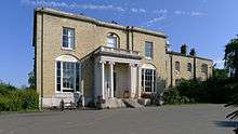 |
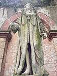
| Bronze Statue of Edward VI at St Thomas' Hospital | Lambeth
(The statue is inside St Thomas' Hospital between the North Wing and the South Wing, before Central Hall) |
Statue | 1736 | 30 May 1979 | TQ3062879480 51°29′57″N 0°07′10″W / 51.499173°N 0.119503°W |
1080372 |  |
| Brunswick House | 30 Wandsworth Road, Vauxhall | House | Late 18th century | 26 March 1973 | TQ3018177864 51°29′05″N 0°07′36″W / 51.484754°N 0.126535°W |
1357952 | 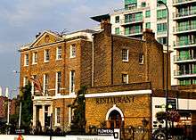 |
| Christ Church | Brixton Road, SW9 | Church | 1907 | 19 October 1951 | TQ3114477090 51°28′39″N 0°06′47″W / 51.477576°N 0.112961°W |
1358218 |  |
| Church of Holy Trinity | Clapham Common North Side | Church | 1774–1776 | 14 July 1955 | TQ2916575361 51°27′45″N 0°08′31″W / 51.462492°N 0.142073°W |
1080491 |  |
| Church of St John with All Saints | Waterloo Road, Waterloo SE1 | Church | 1823-4 | 19 October 1951 | TQ3113380093 51°30′16″N 0°06′43″W / 51.504565°N 0.112005°W |
1357954 | .JPG) |
| Church of St Luke | Norwood High Street, West Norwood | Church | 1822 | 27 March 1981 | TQ3193272074 51°25′56″N 0°06′13″W / 51.432316°N 0.10349°W |
1116506 | 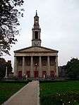 |
| Church of St Mark | Kennington Park Road, Kennington Oval | Church | 1822–24 | 19 October 1951 | TQ3120677520 51°28′53″N 0°06′43″W / 51.481426°N 0.111909°W |
1080383 |  |
| Church of St Mary | Lambeth Road, Lambeth (now Garden Museum) | Church | 1377 | 19 October 1951 | TQ3059779013 51°29′42″N 0°07′12″W / 51.494983°N 0.120122°W |
1080380 | .jpg) |
| Church of St Matthew | Brixton Hill, Brixton | Church | 1822-4 | 19 October 1951 | TQ3098875093 51°27′35″N 0°06′57″W / 51.459665°N 0.115945°W |
1080532 | 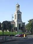 |
| Church of St Paul | Rectory Grove, Clapham | Church | 1815 | 14 July 1955 | TQ2926776074 51°28′08″N 0°08′25″W / 51.468877°N 0.140345°W |
1121980 |  |
| Church of St Peter, Leigham Court Road | Streatham | Church | 1871 | 27 March 1981 | TQ3115072004 51°25′55″N 0°06′53″W / 51.431868°N 0.114759°W |
1065037 |  |
| St Peter's Church, Kennington Lane | 310 Kennington Lane, Vauxhall | Church | 1863-4 | 22 October 1974 | TQ3072278103 51°29′12″N 0°07′07″W / 51.486777°N 0.118659°W |
1358276 | 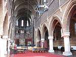 |
| Forecourt Walls, Railings and Gate to Number 23 Old Town | Clapham | Gate | Early 19th century | 27 March 1979 | TQ2922175649Fgipsy 51°27′54″N 0°08′28″W / 51.465068°N 0.141162°W |
1323174 | 
|
| Forecourt Walls, Railings and Gates to Numbers 12 to 21 (consecutive) Clapham Common Northside | Clapham Common, Lambeth | Gate | 18th century | 27 March 1981 | TQ2903875349 51°27′45″N 0°08′38″W / 51.462413°N 0.143905°W |
1080494 |
|
| Former St Peter's School | 38 St Oswald's Place, Kennington | Teachers House | 1860-1 | 27 January 1981 | TQ3072678133 51°29′13″N 0°07′07″W / 51.487045°N 0.118591°W |
1064944 |  |
| Front Walls, Railings and Gates to Numbers 39,41 and 43 Old Town | Clapham | Gate | Early 19th century | 27 March 1979 | TQ2922875549 51°27′51″N 0°08′28″W / 51.464168°N 0.141098°W |
1065001 |
|
| Herbert House | 312 Kennington Lane, Kennington | Orphanage/clergy training college | 1860-2 | 27 March 1981 | TQ3070678085 51°29′12″N 0°07′08″W / 51.486619°N 0.118896°W |
1185572 |  |
| Lodge at Entrance to Kennington Park | Kennington | Model Houses for Four Families | 1851 | 8 September 1961 | TQ3136277849 51°29′04″N 0°06′34″W / 51.484346°N 0.109542°W |
1185790 |  |
| Main Block of the County Hall | South Bank | County Hall | 1911–33 | 19 October 1951 | TQ3065979791 51°30′07″N 0°07′08″W / 51.501961°N 0.118942°W |
1358192 | 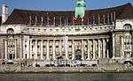 |
| Mausoleum of Richard Budd in Grounds of Church of St Matthew | Brixton Hill, Brixton | Mausoleum | 1824 | 27 March 1981 | TQ3098975193 51°27′38″N 0°06′57″W / 51.460564°N 0.115894°W |
1080574 | 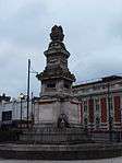 |
| Old Vic Theatre | Waterloo | Theatre | 1816–18 | 19 October 1951 | TQ3132779813 51°30′07″N 0°06′34″W / 51.502004°N 0.109315°W |
1068710 |  |
| Pullman Court | 1–218 Streatham Hill, Streatham | Flats | 1933-5 | 16 January 1981 | TQ3046473252 51°26′36″N 0°07′27″W / 51.443242°N 0.124162°W |
1064939 | 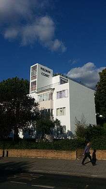 |
| Roman Catholic Chapel of Corpus Christi | Brixton Hill | Roman Catholic Church | 1886 | 27 January 1981 | TQ3075574673 51°27′21″N 0°07′10″W / 51.455945°N 0.119452°W |
1080535 | 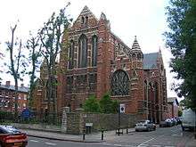 |
| Roman Catholic Church of St Mary (church of the Redemptionist Fathers) | Clapham Park Road, Clapham | Roman Catholic Church | 1849–51 | 8 February 1979 | TQ2949075270 51°27′42″N 0°08′15″W / 51.4616°N 0.137431°W |
1358240 |
|
| Roman Catholic Church of the English Martyrs | Mitcham Lane, Streatham | Roman Catholic Church | Built 1892-4 | 27 March 1981 | TQ2996671648 51°25′44″N 0°07′55″W / 51.428941°N 0.131912°W |
1357894 |  |
| Royal National Theatre | South Bank | Workshop | 1969–76 | 23 June 1994 | TQ3101380383 51°30′26″N 0°06′49″W / 51.507199°N 0.113625°W |
1272324 |  |
| St Mary's Redemptorist Monastery | Clapham Park Road, Clapham | Monastery | Late 19th century | 8 February 1979 | TQ2948875230 51°27′40″N 0°08′15″W / 51.461241°N 0.137474°W |
1300154 |
|
| Stockwell Bus Garage | Binfield Road, Stockwell | Bus Depot | 1952-3 | 29 March 1988 | TQ3035976686 51°28′27″N 0°07′28″W / 51.474126°N 0.124407°W |
1249757 |  |
| Stone Statue of Edward VI at St Thomas' Hospital | Lambeth
Outside main entrance (north entrance to North Block) to St Thomas' Hospital, off Westminster Bridge Road, Lambeth |
Statue | 1682 | 30 May 1979 | TQ3067279548 51°29′59″N 0°07′08″W / 51.499774°N 0.118845°W |
1319933 | 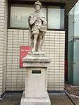 |
| The Academy (formerly Astoria Theatre) | Brixton | Cinema | 1929 | 16 January 1974 | TQ3104175755 51°27′56″N 0°06′54″W / 51.465602°N 0.114938°W |
1064934 | .jpg) |
| The Belgrave Hospital for Children | Clapham Road, Kennington Oval, SW9 | Childrens Hospital | 1903 | 27 March 1981 | TQ3112277443 51°28′51″N 0°06′47″W / 51.480753°N 0.113147°W |
1358241 |  |
| Brixton Windmill | Brixton Hill | Windmill | 1816 | 19 October 1951 | TQ3045874362 51°27′12″N 0°07′26″W / 51.453218°N 0.123839°W |
1080573 | 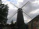 |
| The South Bank Lion at East End of Westminster Bridge | South Bank | Sculpture | 1837 | 27 March 1981 | TQ3059979676 51°30′03″N 0°07′11″W / 51.500941°N 0.119848°W |
1068742 | 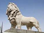 |
| Tomb of Admiral Bligh in St Mary's Churchyard | Garden Museum, Lambeth Road, Lambeth | Tomb | 1817 | 27 March 1981 | TQ3062779006 51°29′42″N 0°07′11″W / 51.494914°N 0.119693°W |
1116226 | 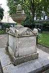 |
| Tomb of John Tradescant and His Family in St Mary's Churchyard | Garden Museum, Lambeth Road, Lambeth | Tomb | 1662 | 27 March 1981 | TQ3062678998 51°29′41″N 0°07′11″W / 51.494842°N 0.11971°W |
1116214 |  |
| Tomb of William Sealy in St Mary's Churchyard | Outside the Garden Museum, Lambeth Road, Lambeth | Tomb | 1800 | 27 March 1981 | TQ3057779000 51°29′42″N 0°07′13″W / 51.494871°N 0.120415°W |
1080381 |  |
| Vauxhall Bridge | Lambeth | Road Bridge with Sculpture | 1904–06 | 26 November 2008 | TQ3018578145 51°29′14″N 0°07′35″W / 51.487278°N 0.126374°W |
1393012 |  |
| Villa on South West Corner of St Michaels Convent (formerly Known As Park Hill) | Streatham Common North, Streatham | Villa | c. 1835 | 27 March 1981 | TQ3103471150 51°25′27″N 0°07′00″W / 51.42422°N 0.116742°W |
1064936 |
|
| Waterloo Bridge | Lambeth | Road Bridge | 1939–1945 | 16 January 1981 | TQ3079680504 51°30′30″N 0°07′00″W / 51.508336°N 0.116705°W |
1081053 | 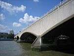 |
| Waterworks Pumping Station | Conyers Road, Streatham | Water Pumping Station | Late 19th century | 27 March 1981 | TQ2955871000 51°25′24″N 0°08′17″W / 51.423211°N 0.138014°W |
1358229 |  |
| West Norwood Memorial Park Augustus Ralli Mortuary Chapel in the Greek Burial Ground | West Norwood | Mortuary Chapel | c. 1872 | 8 April 1974 | TQ3240872248 51°26′02″N 0°05′48″W / 51.433769°N 0.096581°W |
1064989 | 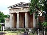 |
| West Norwood Memorial Park Mausoleum of Sir Henry Tate | West Norwood | Mausoleum | c. 1890 | 27 March 1981 | TQ3240772150 51°25′58″N 0°05′48″W / 51.432888°N 0.096632°W |
1065025 | 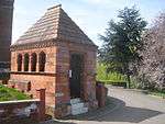 |
| West Norwood Memorial Park Mausoleum of JP Ralli West of Gate in the Greek Burial Ground | West Norwood | Mausoleum | c. 1863 | 27 March 1981 | TQ3241472270 51°26′02″N 0°05′47″W / 51.433965°N 0.096487°W |
1357927 | 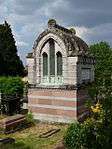 |
| West Norwood Memorial Park Tomb of Alexander Berens | West Norwood | Chest Tomb | c. 1858 | 27 March 1981 | TQ3232072051 51°25′55″N 0°05′53″W / 51.432019°N 0.09792°W |
1065022 | 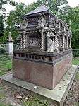 |
| West Norwood Memorial Park Tomb of Doctor Gideon Mantell | West Norwood | Tomb | c. 1852 | 27 March 1981 | TQ3219172082 51°25′56″N 0°05′59″W / 51.432327°N 0.099763°W |
1106387 |  |
| West Norwood Memorial Park Tomb of John Britton | West Norwood | Tomb | c. 1857 | 27 March 1981 | TQ3206872198 51°26′00″N 0°06′05″W / 51.433398°N 0.101488°W |
1106239 |  |
| West Norwood Memorial Park Tomb of William and Elizabeth Burges | West Norwood | Chest Tomb | c. 1855 | 27 March 1981 | TQ3242271997 51°25′53″N 0°05′47″W / 51.43151°N 0.096474°W |
1064984 |  |
| Westminster Bridge | Lambeth | Road Bridge | 1862 | 5 February 1970 | TQ3046879663 51°30′03″N 0°07′18″W / 51.500854°N 0.121739°W |
1066172 | 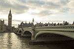 |
| Westminster Bridge | Lambeth | Bridge | 1862 | 5 February 1970 | TQ3055079661 51°30′03″N 0°07′14″W / 51.500818°N 0.12056°W |
1081058 | |
| Woodstock Court | 2 and 20 Newburn Street, Kennington | Two story almshouse-style quadrangle with central fountain | 1914 | 27 March 1981 | TQ3096978423 51°29′23″N 0°06′54″W / 51.489595°N 0.114986°W |
1320423 | 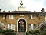 |
| 39, 41 and 43 Old Town | Clapham, SW4 | House | Early-mid 18th century | 14 July 1955 | TQ2924175545 51°27′51″N 0°08′27″W / 51.464129°N 0.140912°W |
1065000 |
|
| 350 and 352 Kennington Road | Lambeth | Terrace | Early 19th century | 19 October 1951 | TQ3117878050 51°29′10″N 0°06′44″W / 51.486195°N 0.112115°W |
1186098 | 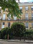 |
| 155 and 157 Kennington Lane SE11 | Kennington, SE11 | House | mid 18th century | 19 October 1951 | TQ3133478375 51°29′21″N 0°06′35″W / 51.489079°N 0.109749°W |
1299526 |  |
| Terrace, 12–21 Clapham Common North Side SW4 | Clapham Common, SW4 | Terrace | c. 1720 | 14 July 1955 | TQ2900775360 51°27′45″N 0°08′40″W / 51.462519°N 0.144346°W |
1080493 | |
Notes
- 1 2 The date given is the date used by Historic England as significant for the initial building or that of an important part in the structure's description.
- 1 2 Sometimes known as OSGB36, the grid reference is based on the British national grid reference system used by the Ordnance Survey.
- 1 2 The "List Entry Number" is a unique number assigned to each listed building and scheduled monument by Historic England.
External links
-
 Media related to Grade I listed buildings in the London Borough of Lambeth at Wikimedia Commons
 - Media related to Grade II* listed buildings in the London Borough of Lambeth at Wikimedia Commons
| Districts |  | |
|---|---|---|
| Attractions |
| |
| Bridges | ||
| Parks and open spaces |
| |
| Constituencies | ||
| Tube, rail, and riverboat stations | ||
| Other topics | ||
This article is issued from
Wikipedia.
The text is licensed under Creative Commons - Attribution - Sharealike.
Additional terms may apply for the media files.