Gottmadingen
| Gottmadingen | ||
|---|---|---|
| ||
 Gottmadingen | ||
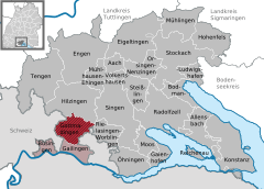
Location of Gottmadingen within Konstanz district 
 | ||
| Coordinates: 47°44′8″N 8°46′36″E / 47.73556°N 8.77667°ECoordinates: 47°44′8″N 8°46′36″E / 47.73556°N 8.77667°E | ||
| Country | Germany | |
| State | Baden-Württemberg | |
| Admin. region | Freiburg | |
| District | Konstanz | |
| Government | ||
| • Mayor | Michael Klinger | |
| Area | ||
| • Total | 23.59 km2 (9.11 sq mi) | |
| Elevation | 437 m (1,434 ft) | |
| Population (2015-12-31)[1] | ||
| • Total | 10,357 | |
| • Density | 440/km2 (1,100/sq mi) | |
| Time zone | CET/CEST (UTC+1/+2) | |
| Postal codes | 78244 | |
| Dialling codes | 07731 | |
| Vehicle registration | KN | |
| Website | www.gottmadingen.de | |
Gottmadingen is a municipality in the district of Konstanz, in Baden-Württemberg, Germany. It is situated next to the border to Switzerland, 5 km southwest of Singen, and 12 km east of Schaffhausen.
Gottmadingen's first documentary mention was in 965. Until the construction of the railway Singen - Schaffhausen it was a tiny village. Economic growth began in the 20th century. Due to the big demand for workers in the new factories the number of inhabitants grew rapidly
Gottmadingen's industry was mainly based on the production of agricultural machinery. In the years 1960 - 70 more than 4000 workers were employed in the "Fahr" factory for agricultural engines. The factory was closed in 2003.
Today's economy is based on several companies that settled on the former "Fahr" factory area.
