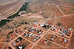
Gochas
| Gochas | |
|---|---|
|
Gochas from bird's eye view (2017) | |
 Gochas | |
| Coordinates: 24°47′S 18°49′E / 24.783°S 18.817°ECoordinates: 24°47′S 18°49′E / 24.783°S 18.817°E | |
| Country |
|
| Time zone | SAST (UTC+1) |
| Climate | BWh |
Gochas is a village in the Hardap Region of Namibia. It is located 110 kilometres (68 mi) southeast of Mariental[1] on the way to the Mata Mata border post to the Kgalagadi Transfrontier Park.[2] The village has been the main settlement of the ǃKharakhoen (Fransman Nama), a subtribe of the Nama people,[3] since 1889.[4]
Gochas is governed by a village council that currently has five seats.[5]
References
- ↑ Cloete, Luqman (24 November 2005). "Ministry takes up probe of problems at Gochas". The Namibian.
- ↑ "Gochas". Namibweb. Retrieved 10 July 2011.
- ↑ Malan, Johan S (1998). Die Völker Namibias [The Tribes of Namibia] (in German). Windhoek, Göttingen: Klaus Hess. pp. 120–125.
- ↑ Dierks, Klaus. "Biographies of Namibian Personalities, K". Retrieved 9 July 2011.
- ↑ "Know Your Local Authority". Election Watch (3). Institute for Public Policy Research. 2015. p. 4.
This article is issued from
Wikipedia.
The text is licensed under Creative Commons - Attribution - Sharealike.
Additional terms may apply for the media files.
