Gmina Cisek
| Gmina Cisek Gemeinde Czissek Cisek Commune | ||
|---|---|---|
| Gmina | ||
|
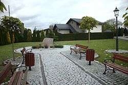
Park in Dzielnica | ||
| ||
| Coordinates (Cisek): 50°17′N 18°12′E / 50.283°N 18.200°ECoordinates: 50°17′N 18°12′E / 50.283°N 18.200°E | ||
| Country |
| |
| Voivodeship | Opole | |
| County | Kędzierzyn-Koźle | |
| Seat | Cisek | |
| Area | ||
| • Total | 70.89 km2 (27.37 sq mi) | |
| Population (2006) | ||
| • Total | 6,768 | |
| • Density | 95/km2 (250/sq mi) | |
| Website | http://www.cisek.gmina.pl | |
Gmina Cisek, German Gemeinde Czissek is a rural gmina (administrative district) in Kędzierzyn-Koźle County, Opole Voivodeship, in south-western Poland. Its seat is the village of Cisek (Czissek), which lies approximately 8 kilometres (5 mi) south of Kędzierzyn-Koźle and 47 km (29 mi) south-east of the regional capital Opole.
The gmina covers an area of 70.89 square kilometres (27.4 sq mi), and as of 2006 its total population is 6,768. Since 2007 the commune has been bilingual in German and Polish, and has its signs in two languages. These signs celebrate the multicultural past of the region, which was prior to 1945 part of Germany and still maintains a large German population.
Administrative divisions
The commune contains the villages and settlements of:
- Cisek / Czissek
- Błażejowice / Blaseowitz
- Dzielnica / Dzielnitz
- Kobylice / Kobelwitz
- Landzmierz / Landsmierz
- Łany / Lohnau
- Miejsce Odrzańskie / Mistitz
- Nieznaszyn / Niesnaschin
- Podlesie / Podlesch
- Przewóz / Przewos
- Roszowice / Roschowitzdorf
- Roszowicki Las / Roschowitzwald
- Steblów / Stöblau
- Sukowice / Suckowitz
Neighbouring gminas
Gmina Cisek is bordered by the gminas of Kuźnia Raciborska and Rudnik.
Gallery
 Bridge in Błażejowice
 Barn in Roszowicki Las
 Village chapell in Nieznaszyn
References
- Polish official population figures 2006
- List of minority place names

Wikimedia Commons has media related to Gmina Cisek.


