Great Kills (Staten Island Railway station)
| Staten Island Railway rapid transit station | ||||||||||||||||||||
|
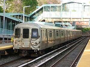
A Staten Island Railway train terminating at Great Kills Station. | ||||||||||||||||||||
| Station statistics | ||||||||||||||||||||
| Address |
Giffords Lane & Brower Court Staten Island, NY 10308 | |||||||||||||||||||
| Borough | Staten Island | |||||||||||||||||||
| Locale | Great Kills | |||||||||||||||||||
| Coordinates | 40°33′05″N 74°09′05″W / 40.55125°N 74.15132°WCoordinates: 40°33′05″N 74°09′05″W / 40.55125°N 74.15132°W | |||||||||||||||||||
| Services | SIR Main Line | |||||||||||||||||||
| Transit connections |
| |||||||||||||||||||
| Structure | Open-cut | |||||||||||||||||||
| Platforms | 2 side platforms | |||||||||||||||||||
| Tracks | 2 | |||||||||||||||||||
| Other information | ||||||||||||||||||||
| Opened |
April 23, 1860,[1] Rebuilt 1933 Upgraded 1997 | |||||||||||||||||||
| Station code | 513[2] | |||||||||||||||||||
| Accessible |
| |||||||||||||||||||
| Former/other names |
Gifford's Gifford's Lane | |||||||||||||||||||
| Station succession | ||||||||||||||||||||
| ||||||||||||||||||||
| ||||||||||||||||||||
Great Kills is a Staten Island Railway station in the neighborhood of Great Kills, Staten Island, New York. It is located on an open cut southwest of Giffords Lane and Amboy Road on the main line. It has two side platforms and turquoise blue canopies and walls.
History
The station's original name was Gifford's, which named after the neighborhood of Giffords, which was named after Daniel Gifford, a local commissioner and surveyor. The name also survives in Giffords Lane, which is located at the station.[1][3][4] The station was also known as Gifford's Lane.[1] Both names appeared on the October 16, 1921 timetable.[5]
The station opened on April 23, 1860, with the opening of the Staten Island Railway from Vanderbilt's Landing to Eltingville.[1][6] It was rebuilt again in the early 1930s, but with great difficulty. Workers had to dig 30 feet below ground level in order to avoid the underground springs and deep quicksand that laced the vicinity of the right-of-way. The project was finished by 1933.
Station layout
| G | Street level | Exit/Entrance |
| P Platforms |
Side platform, doors will open on the right | |
| Southbound | ← Tottenville (rush hours) toward Tottenville (Eltingville) ← Great Kills (rush hours) termination track, (other times) toward Tottenville (Eltingville) | |
| Northbound | → St. George toward St. George (Bay Terrace) → | |
| Side platform, doors will open on the right | ||
This station is handicapped-accessible in compliance with the Americans with Disabilities Act via a pair of long ramps. In addition, there are stairs and an overpass leading to Brower Court and Nelson Avenue. The Great Kills Veterans Memorial is outside the entrance on the northbound side. The north end at Giffords Lane has the standard SIRT street-level stationhouse, and staircases leading to a heavily used commercial district.
Peak direction afternoon rush hour express trains from St. George end their non-stop runs at this station. Local trains operating in the peak direction begin or end their runs here. New switches were installed in 1997 south of the platforms. The remains of a spur are visible in this area. The New York City Department of Transportation operates a park and ride lot at the station.
References
- 1 2 3 4 Irvin Leigh and Paul Matus (December 23, 2001). "SIRT The Essential History". p. 4. Archived from the original on January 4, 2009. Retrieved 2009-03-03.
- ↑ "Station Developers' Information". Metropolitan Transportation Authority. Retrieved June 13, 2017.
- ↑ Sidewinders By Avram Mednick Page 50
- ↑
- ↑
- ↑ Poster for opening of Staten Island Railway
External links
![]() Media related to Great Kills (Staten Island Railway station) at Wikimedia Commons
Media related to Great Kills (Staten Island Railway station) at Wikimedia Commons
- Staten Island Railway station list
- Staten Island Railway general information
- Giffords Lane entrance from Google Maps Street View
- Nelson Avenue (handicap) entrance from Google Maps Street View
- Platforms from Google Maps Street View


