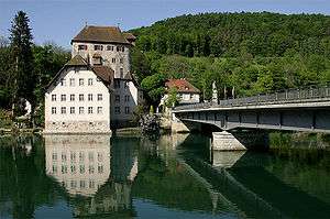
German–Switzerland border

The border between the modern states of Germany and Switzerland extends to 362 km,[1] mostly following the High Rhine between Lake Constance and Basel.
Much of the border is within the sphere of the Zurich metropolitan area and there is substantial traffic, both for commuting and for shopping across the border; line S22 of the suburban Zürich S-Bahn even running across German territory, and the Swiss municipality of Kreuzlingen forming part of the conurbation of German Constance. Similarly, Basel metropolitan area includes territory in both France and Germany.
History
The High Rhine has had the character of the northern border of the Old Swiss Confederacy since the Swabian War and the accession of Basel in 1499–1501, dividing the Swiss Confederacy from the Swabian Circle of the Holy Roman Empire; with the Peace of Westphalia of 1648, the border acquired the status of an international border de jure.
With minor changes (such as the acquisition of Rafzerfeld in 1651), it remained unchanged since, even throughout the Napoleonic era when it divided two French client states (Cisrhenian Republic and Helvetic Republic) and later the Confederation of the Rhine from the restored Swiss Confederacy, and eventually the German Confederation from modern Switzerland. The border persisted even during the Nazi era (although with the Anschluss of Austria, the German-Swiss border technically included the Austrian-Swiss border from 1938 and until the formation of the German Federal Republic in 1949).
On 12 December 2008 Switzerland implemented the Schengen Agreement lifting all land and water border controls along this border, and a little later for Swiss airports.
In mid-2016, during the European migrant crisis, the German government deployed an additional 90 border guards and 40 police officers in order to reduce the level of illegal immigration passing through Switzerland.[2][3]
Geography

The German-Swiss border begins in at the German-Swiss-Austrian tripoint, which is located in the Lake Constance, approximately at 47°33′N 9°35′E / 47.550°N 9.583°E. The border makes landfall south of Constance. The Lake Constance divides the German Bodenseekreis from the Swiss canton of Thurgau. The stretch of border (c. 1.5 km) dividing Constance from Kreuzlingen comprises the only territory of Germany on the left bank of the High Rhine. The border then runs along the Untersee, passing south of Reichenau. At the lake's exit it turns inland, towards the north, leaving Stein am Rhein within Switzerland, as well as the municipality of Ramsen (canton of Schaffhausen). It then returns to the Rhine, including Gailingen in Germany, but then turns north again to include the bulk of the canton of Schaffhausen, a right-bank territory including the town of Schaffhausen itself, in Switzerland, separating it from the German Schwarzwald-Baar-Kreis and Waldshut district. Büsingen am Hochrhein (Constance district) is a German enclave bordering on the cantons of Schaffhausen and Thurgau.
The border returns to the Rhine downstream of the Rhine Falls, now separating the Waldshut district from the canton of Zürich, but then deviates from the river again to include the Rafzerfeld plain into Zürich's Bülach district (a right-bank territory historically acquired by the city of Zürich from the counts of Sulz in 1651).
Downstream of Rafzerfeld, the border now sticks to the course of the Rhine until it enters the city of Basel, now forming the northern border of the canton of Aargau as far as Kaiseraugst and then the canton of Basel-Land (municipalities of Pratteln and Muttenz) bordering on the German Lörrach district.
Besides the right-bank part of Basel proper (Lesser Basel) the border also includes the right-bank municipalities of Riehen and Bettingen into the canton of Basel Stadt. The border then cuts across the E35 south of Weil am Rhein and back to the Rhine, where it terminates in the French-German-Swiss tripoint, dividing into the French-German and the French-Swiss borders. The tripoint is located in the river Rhine at 47°35′23″N 7°35′20″E / 47.58972°N 7.58889°E. A monument has been built near it, known as the Dreiländereck.
External links
| Wikimedia Commons has media related to Borders of Germany-Switzerland. |
References
- ↑ National boundary (swisstopo); this figure includes the border of the German enclave Büsingen am Hochrhein.
- ↑ "Germany Toughens Swiss Border Against Illegal Migrants". Deutsche Welle. August 21, 2016. Retrieved February 11, 2017.
- ↑ "Germany Tightens Border Controls with Switzerland to Stop Illegal Immigrants, Says Swiss Minister". The Independent. August 2016. Retrieved February 11, 2017.
- Thomas Wüthrich, Adrian Wiget, Beitrag zur Konstruktion der Landesgrenze Deutschland – Schweiz im Untersee swisstopo (2008).