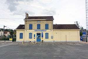
Gare de Presles-Courcelles
 Station building | |||||||||||
| Location |
Place du Général Leclerc | ||||||||||
| Coordinates | 49°6′49″N 2°17′16″E / 49.11361°N 2.28778°ECoordinates: 49°6′49″N 2°17′16″E / 49.11361°N 2.28778°E | ||||||||||
| Owned by | SNCF | ||||||||||
| Line(s) | Épinay-Villetaneuse–Le Tréport-Mers railway | ||||||||||
| Platforms | 2 outside | ||||||||||
| Tracks | 2 | ||||||||||
| Construction | |||||||||||
| Parking | 300 | ||||||||||
| Other information | |||||||||||
| Fare zone | 5 (Orange Card) | ||||||||||
| Website | The station at Transilien (in French) | ||||||||||
| History | |||||||||||
| Opened | 1880 | ||||||||||
| Traffic | |||||||||||
| Passengers (2002) | fewer than 500[1] | ||||||||||
| Services | |||||||||||
| |||||||||||
The Gare de Presles - Courcelles (Presles - Courcelles Station) is a railway station located in Presles (Val d'Oise department), France, near the hamlet of Courcelles. It is on the Épinay-Villetaneuse–Le Tréport-Mers railway. The station is used by Transilien line H trains from Paris to Persan-Beaumont. The Nord railway company opened the line from Épinay to Persan - Beaumont in 1877.[2]
References
- ↑ Stif - Atlas des transports publics en Île-de-France (in French)
- ↑ Michel Rival, Le Refoulons, ou, Le chemin de fer d'Enghien à Montmorency: petite histoire d'une grande ligne, 1866-1954, Paris: Valhermeil, 1989, ISBN 2-905684-20-8, p. 248. (in French)
External links
| Wikimedia Commons has media related to Gare de Presles - Courcelles. |
- Gare de Presles - Courcelles at SNCF Transilien (in French)
This article is issued from
Wikipedia.
The text is licensed under Creative Commons - Attribution - Sharealike.
Additional terms may apply for the media files.