Galyang Municipality
| Galyang गल्याङ | |
|---|---|
| Municipality | |
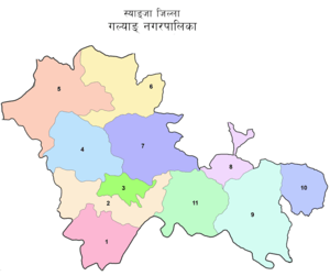
 Administrative divisions of Galyang | |
 Galyang Location in Nepal | |
| Coordinates: 27°56′22″N 83°38′07″E / 27.939422°N 83.635153°ECoordinates: 27°56′22″N 83°38′07″E / 27.939422°N 83.635153°E | |
| Country |
|
| Nepalese Federal States | Province No. 4 |
| District | Syangja District |
| Area | |
| • Total | 122.69 km2 (47.37 sq mi) |
| Population (2011 Nepal census) | |
| • Total | 36,967 |
| • Density | 300/km2 (780/sq mi) |
| Time zone | Nepal Time (UTC+5:45) |
Galyang (Nepali: गल्याङ) is a Municipality in Syangja District in the Province No. 4 of central Nepal. In 12 March 2017, The government of Nepal implemented the new local administrative structure consisting of 744 local units.[1] With the implementation of this new local administrative structure, VDCs have been replaced with village councils. Galyang is one of these 744 local municipal units.[2] Galyang is created by merging Malunga, Jagatradevi, (1-6,9) Wards of Pakwadi, (1,6-9) Wards of Tindobate, Tulsibhanjyang, Nibuwakharka, Pidikhola & (1-4,7-9) Wards of Pelakot.[3]
Political situation
Galyang is divided into 11 Wards. It is surrounded by Parbat District at northern side, Chapakot Municipality & Waling from east, Kaligandaki and Gulmi District from west and Palpa District at south. Jagatradevi is its headquarter.[2]
Population
Galyang is created by merging Malunga, Jagatradevi, (1-6,9) Wards of Pakwadi, (1,6-9) Wards of Tindobate, Tulsibhanjyang, Nibuwakharka, Pidikhola & (1-4,7-9) Wards of Pelakot. The sum population of Galyang, 36,967, is residing in an area of 122.69 km2.[4]
References
- ↑ "744 new local units come into effect". The Kathmandu Post. Retrieved 15 March 2017.
- 1 2 "Which local units are you in?". Seto Pati. Retrieved 16 March 2017.
- ↑ "Which local unit do you belong to?". MyRepublica. Retrieved 11 March 2017.
- ↑ "Syangja VDC Level Report" (PDF). Central Bureau of Statistics. Archived from the original (PDF) on 2014-10-26.