Friesack (Amt)
Friesack is an Amt ("municipal federation") in the district of Havelland, in Brandenburg, Germany. Its seat is in Friesack.
The Amt Friesack consists of the following municipalities:
- Friesack
- Mühlenberge
- Paulinenaue
- Pessin
- Retzow
- Wiesenaue
Demography
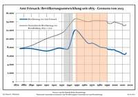
Development of Population since 1875 within the Current Boundaries (Blue Line: Population; Dotted Line: Comparison to Population Development of Brandenburg state; Grey Background: Time of Nazi rule; Red Background: Time of Communist rule)
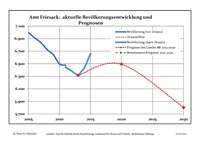
Recent Population Development (Blue Line) and Forecasts
Amt Friesack:
Population development within the current boundaries (2013)[1]
| Year |
Population |
|---|
| 1875 | 7 721 |
| 1890 | 7 716 |
| 1910 | 7 159 |
| 1925 | 7 805 |
| 1933 | 7 682 |
| 1939 | 7 799 |
| 1946 | 11 727 |
| 1950 | 11 954 |
| 1964 | 9 054 |
| 1971 | 8 969 |
|
|
| Year |
Population |
|---|
| 1981 | 8 050 |
| 1985 | 7 965 |
| 1989 | 7 812 |
| 1990 | 7 661 |
| 1991 | 7 577 |
| 1992 | 7 528 |
| 1993 | 7 502 |
| 1994 | 7 531 |
| 1995 | 7 456 |
| 1996 | 7 425 |
|
|
| Year |
Population |
|---|
| 1997 | 7 438 |
| 1998 | 7 477 |
| 1999 | 7 408 |
| 2000 | 7 396 |
| 2001 | 7 245 |
| 2002 | 7 174 |
| 2003 | 7 116 |
| 2004 | 7 055 |
| 2005 | 6 995 |
| 2006 | 6 912 |
|
|
| Year |
Population |
|---|
| 2007 | 6 837 |
| 2008 | 6 728 |
| 2009 | 6 645 |
| 2010 | 6 497 |
| 2011 | 6 445 |
| 2012 | 6 380 |
| 2013 | 6 314 |
| 2014 | 6 429 |
| 2015 | 6 658 |
|
|
References
- ↑ Detailed data sources are to be found in the Wikimedia Commons.Population Projection Brandenburg at Wikimedia Commons
Coordinates: 52°42′00″N 12°36′00″E / 52.700°N 12.600°E / 52.700; 12.600
 Development of Population since 1875 within the Current Boundaries (Blue Line: Population; Dotted Line: Comparison to Population Development of Brandenburg state; Grey Background: Time of Nazi rule; Red Background: Time of Communist rule)
 Recent Population Development (Blue Line) and Forecasts