Meschede
| Meschede | ||
|---|---|---|
|
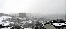
View over Meschede | ||
| ||
 Meschede | ||
Location of Meschede within Hochsauerlandkreis district 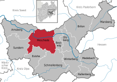
 | ||
| Coordinates: 51°21′N 8°17′E / 51.350°N 8.283°ECoordinates: 51°21′N 8°17′E / 51.350°N 8.283°E | ||
| Country | Germany | |
| State | North Rhine-Westphalia | |
| Admin. region | Arnsberg | |
| District | Hochsauerlandkreis | |
| Government | ||
| • Mayor | Uli Hess (CDU) | |
| Area | ||
| • Total | 218.5 km2 (84.4 sq mi) | |
| Elevation | 260 m (850 ft) | |
| Population (2015-12-31)[1] | ||
| • Total | 30,119 | |
| • Density | 140/km2 (360/sq mi) | |
| Time zone | CET/CEST (UTC+1/+2) | |
| Postal codes | D 59872 | |
| Dialling codes | 0291 | |
| Vehicle registration | HSK | |
| Website | www.meschede.de | |


Meschede is a town in the Hochsauerland district, in North Rhine-Westphalia, Germany. It is the capital of the district Hochsauerlandkreis.
Education
One of the five branches of South Westphalia University of Applied Sciences (also: Fachhochschule Südwestfalen (FH SWF)) is located here.
Geography
Meschede is situated in the Ruhr valley, near to the Hennesee, south of the nature-park Arnsberger Wald. Major towns in the vicinity of Meschede are Paderborn (51 km), Kassel (85 km), Siegen (57 km), Hagen, Dortmund (60 km) and Hamm (49 km).
Neighbouring municipalities
Division of the town
After the local government reforms of 1975 Meschede consists of these districts and villages:
|
|

History
In 1921 the Sauerländer Heimatbund was founded.
Transportation
Meschede is connected with two national roads, the federal roads B 7 and B 55, and the motorway A 46. It has an airfield, the Meschede-Schüren Airfield, with a 900 m runway.
Climate
The city's climate is continental. The lowest temperature recorded was −20 °C (−4 °F), its highest was recorded at 39 °C (102 °F).
Mayors of Meschede
- 1952–1961: Engelbert Dick (CDU)
- 1961–1969: Josef Busch (CDU)
- 1969–1974: Bruno Peus (CDU)
- 1975–1998: Franz Stahlmecke (CDU)
- 1998–1999: Bruno Peus (CDU)
- 1999–present: Hans-Ulrich (Uli) Hess (CDU)
Media
Meschede has its local radio station Radio Sauerland. The Fachhochschule Südwestfalen runs its own radio station called radioFH!. The regional newspapers are Westfalenpost and Westfälische Rundschau. The local newspaper is the Sauerlandkurier.
Notable people
- Karl Lehr (1842–1919), mayor of Duisburg
- August Macke (1887–1914), painter
- Ansgar Nierhoff (b. 1941), artist
- Werner Pieper (b. 1948), author
- Klaus-Jürgen Wrede (b. 1963), author of the Carcassonne games
- Matthias Ungemach (b. 1968), Olympic rower
- Armin Petras (b. 1964), theatre director
- Daniela Bette (b. 1981), actress
- Joseph Hippolyt Pulte (6 October 1811 – died in Cincinnati, Ohio, 24 February 1884) was a homeopathic physician.
- Dieter Wurm, chairman of Sauerländer Heimatbund[2]
Main sights
- Abbey Königsmünster, built by Order of Saint Benedict
- Hennesee - The Hennesee is a lake near Meschede and the main recreational area of the town. It was built to secure the water supply of the close Ruhrgebiet and is today mainly use to generate hydropower, flood protection and baseflow. Recreational areas are the tanning lawn and bath area, fishing, rowing, sailing, walking and hiking.
International relations
Meschede is twinned with:
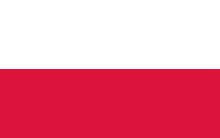 Wińsko, Poland, since 1956
 Le Puy-en-Velay, France, since 1975
- Cousolre, France, since 1965 (twin town of Freienohl)
Also unofficial friendly relations exist with the following towns:
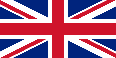 Coventry, United Kingdom
 Coventry, United States
- Vannes, France
 Neufraunhofen, Germany
References
- ↑ "Amtliche Bevölkerungszahlen". Landesbetrieb Information und Technik NRW (in German). 18 July 2016.
- ↑ Sauerländer Heimatbund
External links
- Official site (in German)
| Wikimedia Commons has media related to Meschede. |
Towns and municipalities in Hochsauerland | ||
|---|---|---|