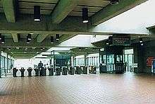
Franconia–Springfield station
 Metro platfrom | |||||||||||||||||||||||||||||||||||||||||
| Location |
6880 Frontier Drive Springfield, Virginia United States | ||||||||||||||||||||||||||||||||||||||||
| Coordinates | 38°45′58″N 77°10′07″W / 38.76611°N 77.16861°WCoordinates: 38°45′58″N 77°10′07″W / 38.76611°N 77.16861°W | ||||||||||||||||||||||||||||||||||||||||
| Owned by | WMATA | ||||||||||||||||||||||||||||||||||||||||
| Line(s) |
| ||||||||||||||||||||||||||||||||||||||||
| Platforms |
1 island platform (Metro) 2 side platforms (VRE) | ||||||||||||||||||||||||||||||||||||||||
| Tracks | 4 (2 for each service) | ||||||||||||||||||||||||||||||||||||||||
| Bus stands | 8 | ||||||||||||||||||||||||||||||||||||||||
| Connections |
| ||||||||||||||||||||||||||||||||||||||||
| Construction | |||||||||||||||||||||||||||||||||||||||||
| Parking | 5,069 spaces | ||||||||||||||||||||||||||||||||||||||||
| Bicycle facilities | 36 racks, 20 lockers | ||||||||||||||||||||||||||||||||||||||||
| Disabled access | Yes | ||||||||||||||||||||||||||||||||||||||||
| Other information | |||||||||||||||||||||||||||||||||||||||||
| Station code | J03 (WMATA) | ||||||||||||||||||||||||||||||||||||||||
| Fare zone | Zone 3 (VREX) | ||||||||||||||||||||||||||||||||||||||||
| History | |||||||||||||||||||||||||||||||||||||||||
| Opened | June 29, 1997[1] | ||||||||||||||||||||||||||||||||||||||||
| Traffic | |||||||||||||||||||||||||||||||||||||||||
| Passengers (2016) |
6,970 daily [2] | ||||||||||||||||||||||||||||||||||||||||
| Services | |||||||||||||||||||||||||||||||||||||||||
| |||||||||||||||||||||||||||||||||||||||||
Franconia–Springfield is an island platformed Washington Metro station in Springfield, Virginia, United States. The station was opened on June 29, 1997, and is operated by the Washington Metropolitan Area Transit Authority (WMATA). Providing service for the Blue Line, it is the southwestern terminus of the Blue Line, and is located at the junction of Franconia-Springfield Parkway and Frontier Drive. The station serves a suburban area and is mostly used for commuters, with 5,069 spaces – Metro's largest parking garage. It is a major transit hub, providing not only Metro service, but also Virginia Railway Express, Metrobus, and local and intercity bus service, including Greyhound buses. It also served as an Amtrak station for the Northeast Regional line between 2003 and 2010. Amtrak's code for the station was "FRS."
With 6,970 daily riders by a 2016 count, Franconia–Springfield station is the 8th-most used WMATA Metro station in Virginia.[2]
History


Prior to construction by WMATA, Franconia–Springfield station was the site of Franconia Station, a standard railroad station built by the Richmond, Fredericksburg and Potomac Railroad. It was built in 1870 and torn down in 1952.[3] Original Metro plans called for 2 separate stations for Franconia and Springfield, but by the time Metro got to building the station, plans had been changed to combine the 2 stations due to the expense and complications of running 2 separate branch lines to the two towns, as it would have required adding an entirely new "color service".
In 1981, WMATA held a series of public hearings to discuss issues related to the expansion of the then Yellow Line to Springfield by 1986, although the project was unfunded at that time.[4] By 1987, the Northern Virginia Transportation Commission began to evaluate whether or not state funding would be necessary to complete the station as federal funding was not guaranteed at that time.[5] By 1991, funding for the expansion was secured and plans for the station, parking garage, and other commuter facilities were approved by the Metro board.[6]
The VRE platform opened in 1995, the second infill station on the system.[7] The Metrorail station opened on June 29, 1997; its opening coincided with the completion of 3.3 miles (5.3 km) of rail west of the Van Dorn Street station.[8][1] The final cost for both the station and rail expansion was $175 million.[9]
In 2003, due to increases in ridership on both the Metro and VRE lines, WMATA opened an additional parking garage on the premises for park-and-ride users, offering an additional 1,000 parking spaces, and bringing the total to 5,100 spaces.[10]
On June 25, 2017, Yellow Line trains stopped serving the station due to the elimination of Rush+, which is part of major changes to the Metrorail system.[11]
Station layout
| P Platform level |
Northbound | → |
| Island platform, doors will open on the left or right | ||
| Northbound | → | |
| M | Mezzanine | One-way faregates, ticket machines, station agent |
| G | Street Level | Exit/Entrance, VRE platform |
References
- 1 2 Tousignant, Marylou (June 27, 1997). "At last, Metro reaches end of the Blue Line; Franconia-Springfield station to begin service on Sunday". The Washington Post. p. B1.
- 1 2 "Metrorail Average Weekday Passenger Boardings" (PDF). WMATA. Retrieved 2017-04-26.
- ↑ Richmond, Fredericksburg & Potomac (TrainWeb)
- ↑ Hodge, Paul (February 26, 1981). "Public hearing set on Springfield Metrorail plans". The Washington Post. p. VA7.
- ↑ Henderson, Nell (January 11, 1987). "Virginia panel to study extending Metro; State funds may be sought to finance Yellow Line to Springfield". The Washington Post. p. B5.
- ↑ Fehr, Stephen C. (June 14, 1991). "Metro plans to build big transportation center at Franconia". The Washington Post. p. C3.
- ↑ Taube, Richard K. (11 August 2008). "Chronology of the Virginia Railway Express: 1964 to Present" (PDF). Virginia Railway Express. Retrieved 16 November 2015.
- ↑ Washington Metropolitan Area Transit Authority (July 2009). "Sequence of Metrorail openings" (PDF). Archived from the original (PDF) on January 13, 2010. Retrieved July 28, 2010.
- ↑ Shear, Michael D. (June 30, 1997). "All aboard Metro at Springfield; Fanfare, new features mark station opening". The Washington Post. p. B1.
- ↑ Metro opens new parking structure at Franconia-Springfield Metrorail station
- ↑ https://www.wmata.com/service/status/details/upload/June25FareServiceChanges_PrintableBrochure_English.pdf
External links
| Wikimedia Commons has media related to Franconia–Springfield (WMATA station). |
- VRE: Franconia/Springfield Station
- WMATA: Franconia–Springfield Station
- StationMasters Online: Franconia–Springfield Station
- The Schumin Web Transit Center: Franconia–Springfield Station
- USA Rail Guide: Franconia–Springfield Station