Nansen Basin

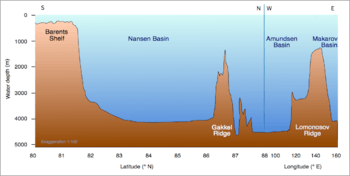
The Nansen Basin (also Central Basin,[1] formerly Fram Basin) is an abyssal plain with water-depths of around 3 km in the Arctic Ocean and (together with the deeper Amundsen Basin) part of the Eurasian Basin. The Nansen Basin fenced by the Gakkel Ridge and by the Barents Sea continental shelf on the other side.[2][3]
The lowest point of the Arctic Ocean lays within the Nansen Basin and has a depth of 4,665 m.[4] The Barents Abyssal Plain is located at the center of the Fram Basin.[5]
Oceanographic situation
The Russian-American cooperation Nansen and Amundsen Basin Observational System (NABOS) aims "to provide a quantitative observationally based assessment of circulation, water mass transformations, and transformation mechanisms in the Eurasian and Canadian Basins of the Arctic Ocean".
Coordinates: 82°N 50°W / 82°N 50°W
References
- ↑ Nordenskjöld, Otto; Ludwig Mecking; Ernst Antevs; Wolfgang Louis Gottfried Joerg; Marion Hale (1928). The Geography of the Polar Regions. American Geographical Society. p. 126.
- ↑ "International Bathymetric Chart of the Arctic Ocean". NOAA.
- ↑ Jakobsson, Martin; Mayer, Larry; Coakley, Bernard; Dowdeswell, Julian A.; Forbes, Steve; Fridman, Boris; Hodnesdal, Hanne; Noormets, Riko; Pedersen, Richard; Rebesco, Michele; Schenke, Hans Werner; Zarayskaya, Yulia; Accettella, Daniela; Armstrong, Andrew; Anderson, Robert M.; Bienhoff, Paul; Camerlenghi, Angelo; Church, Ian; Edwards, Margo; Gardner, James V.; Hall, John K.; Hell, Benjamin; Hestvik, Ole; Kristoffersen, Yngve; Marcussen, Christian; Mohammad, Rezwan; Mosher, David; Nghiem, Son V.; Pedrosa, Maria Teresa; Travaglini, Paola G.; Weatherall, Pauline (29 June 2012). "The International Bathymetric Chart of the Arctic Ocean (IBCAO) Version 3.0". Geophysical Research Letters. 39 (12). doi:10.1029/2012GL052219.
- ↑ "Arctic Ocean". CIA World Factbook. Central Intelligence Agency. Retrieved 2009-07-28.
- ↑ "Towering Mountains". Canada's Aquatic Environments. CyberNatural Software, University of Guelph. Retrieved 2009-07-28.